Caminantes
The Camino from Bilbao to Santiago: the Camino del Norte from Bilbao, day by day
By August Frederik Kramer · Last updated 10 October 2026
- 0
- km walked
- 682.7
- km to Santiago
- m above the sea
- places to sleep mapped on this day
Drag the pilgrim along the profile, or use the slider. Every figure is the day you are on.
Download the poster (PNG)Free to print and share. Please keep caminantes.co on it.
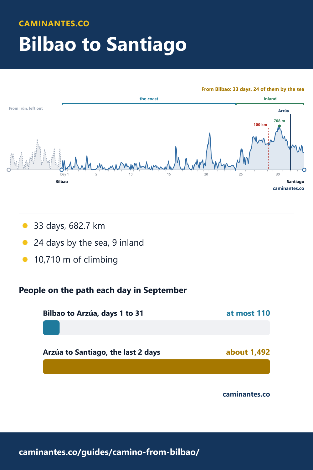
From Bilbao the Camino del Norte is 33 days and 682.7 km to Santiago on our plan, and you climb 10,710 m on the way. The first 24 days follow the coast to Ribadeo; the last 9 cross the green hills of Galicia, and for the final 2 you share the path with the Camino Francés from Arzúa. Starting here leaves out the Basque opening from Irún: 18% of the route’s distance, but 27% of its climbing.
What starting in Bilbao leaves out
The Norte starts in Irún, on the French border, and the 6 days from there to Bilbao are 148.9 km with 3,938 m of climbing: the hilliest part of the route, up and down the Basque coast. Start in Bilbao and you walk 33 days instead of 39, and the climbing drops to 15.7 m per kilometre, against 17.6 from Irún.
Weighing Bilbao against San Sebastián, Santander or Gijón? Where to start the Camino del Norte sets them side by side.
33 days, 20.7 km a day
From Bilbao our plan has 33 days, 20.7 km a day on average. The longest is day 2, Sestao to Sámano, 30.6 km. The steepest is day 20, La Magdalena to Aucinera: 643 m up in 15.5 km, 41.5 m per kilometre, and our map data has no place to sleep on it, so plan the night before and after. Inland, the hardest is day 26, Vilanova to Abadín, 788 m up. Over the whole walk you climb 10,710 m: about the height an airliner cruises at, 35,000 feet or 10,668 m.
The whole route from Irún, stage by stage: the Camino del Norte stages.
The coast, then inland from Ribadeo
Days 1 to 24 run along the coast, 491.0 km from Bilbao to Ribadeo, and every one of them comes down to the sea. At Ribadeo the route turns inland for its last 9 days and 191.7 km, and it does not see the sea again. The coast climbs 15.3 m per kilometre and the inland days 16.6: inland is higher and only a little steeper. The route’s high point, 708 m, comes on day 30, A Bouzaboa to Sobrado.
Arzúa, and the 100 km line
On day 29, A Silvosa to A Bouzaboa, you cross the 100 km line the Compostela asks for; the nearest town far enough out to start from is Vilalba. Day 31 ends in Arzúa, 644.0 km from Bilbao, where the Norte meets the Camino Francés and the Primitivo. The last 2 days, 38.7 km, are one path for all three.
The other route from the north that joins it: the Camino Primitivo. Where every route meets on the way into Santiago: the Camino de Santiago map.
How busy it is: quiet, then Arzúa
The Pilgrim’s Office does not list Bilbao among the 20 starts it counted in 2025, so fewer than 3,646 people set out from there: that is O Porriño, the smallest start on the list. Irún had 5,364. The Norte had 21,481 pilgrims that year; spread over the months the way all Compostelas were, that is at most 110 a day on the path in September, and fewer on the early days. From Arzúa it is about 1,492 a day: 14 times as many.
Know these words before your Camino. Spanish is preparation, the same as boots and stages. Try the free topic
Every day from Bilbao
| Day | Stage | km | m up | Places to sleep |
|---|---|---|---|---|
| 1 | Bilbao → Sestao | 16.6 | 382 | 7 |
| 2 | Sestao → Sámano | 30.6 | 459 | 7 |
| 3 | Sámano → El Puente | 20.8 | 168 | 4 |
| 4 | El Puente → Santoña | 20.4 | 414 | 3 |
| 5 | Santoña → Ajo | 17.7 | 227 | 3 |
| 6 | Ajo → Santander | 25.4 | 164 | 4 |
| 7 | Santander → Arce | 17.3 | 146 | 14 |
| 8 | Arce → Santillana del Mar | 20.0 | 262 | 6 |
| 9 | Santillana del Mar → La Iglesia | 17.7 | 352 | 3 |
| 10 | La Iglesia → San Vicente de la Barquera | 15.6 | 272 | 3 |
| 11 | San Vicente de la Barquera → Colombres | 16.8 | 340 | 4 |
| 12 | Colombres → Llanes | 24.0 | 232 | 4 |
| 13 | Llanes → Ribadesella / Ribeseya | 30.4 | 299 | 7 |
| 14 | Ribadesella / Ribeseya → Colunga | 20.0 | 300 | 3 |
| 15 | Colunga → Villaviciosa | 17.1 | 282 | 3 |
| 16 | Villaviciosa → Gijón / Xixón | 29.9 | 663 | 5 |
| 17 | Gijón / Xixón → Avilés | 26.2 | 264 | 3 |
| 18 | Avilés → L'Arena | 16.7 | 334 | 6 |
| 19 | L'Arena → La Magdalena | 15.8 | 341 | 4 |
| 20 | La Magdalena → Aucinera | 15.5 | 643 | – |
| 21 | Aucinera → Luarca / Ḷḷuarca | 24.7 | 342 | 2 |
| 22 | Luarca / Ḷḷuarca → Navia | 19.8 | 280 | 5 |
| 23 | Navia → Porcía | 15.2 | 199 | 6 |
| 24 | Porcía → Ribadeo | 16.9 | 163 | 2 |
| 25 | Ribadeo → Vilanova | 26.7 | 674 | 3 |
| 26 | Vilanova → Abadín | 25.3 | 788 | 8 |
| 27 | Abadín → Vilalba | 20.5 | 205 | 1 |
| 28 | Vilalba → A Silvosa | 15.8 | 166 | 3 |
| 29 | A Silvosa → A Bouzaboa | 15.4 | 165 | 2 |
| 30 | A Bouzaboa → Sobrado | 27.8 | 429 | 4 |
| 31 | Sobrado → Arzúa | 21.7 | 208 | 8 |
| 32 | Arzúa → O Pedrouzo | 19.5 | 277 | 28 |
| 33 | O Pedrouzo → Santiago | 19.1 | 270 | 30 |
Distances and climbing from our own track and stage plan, the same figures as the stages guide and the starts guide. Places to sleep from map data, so read them as places, not beds; a dash means our data has none for that day, not that there are none. People a day: the Pilgrim’s Office’s 2025 counts, spread over the months the way all Compostelas were.
Common questions
How long is the Camino from Bilbao to Santiago?
682.7 km in 33 days on our plan, 20.7 km a day on average, with 10,710 m of climbing.
How much of the Camino del Norte from Bilbao is on the coast?
The first 24 days, 491.0 km, to Ribadeo. The last 9 days, 191.7 km, are inland.
Do I get the Compostela if I start in Bilbao?
Yes. The Compostela asks for the last 100 km on foot, and the walk from Bilbao is 682.7 km. You cross the 100 km line on day 29.
Where does the Camino del Norte join the Camino Francés?
In Arzúa, at the end of day 31 from Bilbao. The last 38.7 km to Santiago are the same path.
Keep reading
Vigo to Santiago: 5 days, 100.3 km, and 0.3 km to spare
The last hundred of the Camino Portugués from Vigo, measured day by day: the sixth busiest start on any Camino, 458 people a day to Redondela, then 975.
The Camino from Roncesvalles: 35 days, 742.7 km, without the Pyrenees
The Camino Francés from the first town in Spain, measured day by day. Leaving out the Pyrenees day saves 3% of the distance and 13% of the climbing.
Camino de Santiago weather, stage by stage and month by month
The meseta at 28.9 °C on July afternoons, Galicia with rain on 13.5 November days, 4 rainy days on a whole Francés from mid-July: every stage, every month.
Take it with you
Caminantes is free, works offline, and plans your stages around your own legs rather than a guidebook's.