Caminantes
The last 100 km of the Camino de Santiago: where it starts on every route
By August Frederik Kramer · Last updated 29 August 2026
About half of everyone who reaches Santiago walked only the last hundred kilometres of a route, and almost all of them started in one of three towns. Ask where the last 100 km begins and you will be told Sarria, or Tui, or Ferrol, and then the answer stops.
That is not the rule. The rule is a distance, and a distance lands somewhere different on every route. There are seven routes that finish at the cathedral, and the line falls in seven different places, one of which is nowhere near a town anyone advertises. On one of them the obvious starting town, the one every guidebook names, misses the bar by about two hundred metres. On another, a town that thousands of people start from every year clears it by barely a kilometre.
Below is where the line actually falls on each of them, measured along the tracks rather than copied from a brochure.
The rule, in one paragraph
The Compostela goes to anyone who walks the final 100 km into Santiago on one recognised route, continuously, with a stamped credencial, finishing at the cathedral. It is not 100 km anywhere: the last stage has to be the one that arrives. There are real exceptions, including a shorter distance for pilgrims who began a recognised route outside Spain, and there is a widely repeated stamp rule that is not quite what people think it is. All of that is in our guide to getting the Compostela, which states it properly. This page is only about where the 100 km mark sits on the ground.
Where the line falls on every route into Santiago
Each row is the last stage town on that route from which you still clear 100 km, and next to it the following town, which does not. The distances are to the cathedral door.
| Route | Start from | To Santiago | Stages | Climbing | Next town in, which misses |
|---|---|---|---|---|---|
| Camino Primitivo | O Cádavo | 129.9 km | 6 | 1,999 m | Lugo, 99.8 km |
| Camino Francés | Sarria | 114.4 km | 5 | 1,854 m | Portomarín, 92.4 km |
| Camino Inglés | Ferrol | 110.5 km | 6 | 1,800 m | Fene, 92.8 km |
| Vía de la Plata | Ourense | 109.9 km | 6 | 2,336 m | Cea, 92.6 km |
| Camino Invierno | Chantada | 104.9 km | 5 | 1,867 m | Rodeiro, 80.0 km |
| Camino del Norte | A Silvosa | 103.5 km | 5 | 1,349 m | A Bouzaboa, 88.2 km |
| Camino Portugués | O Porriño | 101.2 km | 5 | 1,318 m | Redondela, 85.4 km |
Download this chart as a poster (PNG)Free to use on your blog or in your group. A link back to this page is all we ask.
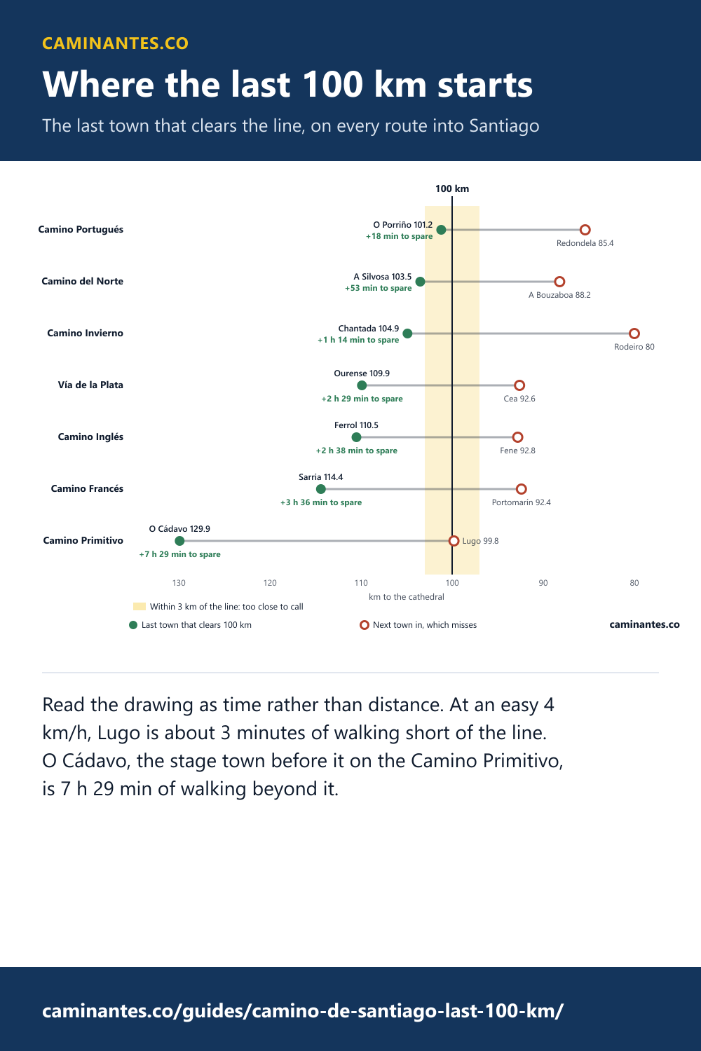
Read the drawing as time rather than distance. At an easy 4 km/h, Lugo is about 3 minutes of walking short of the line. O Cádavo, the stage town before it on the Camino Primitivo, is 7 h 29 min of walking beyond it.
Most starts have hours in hand. The ones inside the gold band have minutes, and a detour or a different mapped line can take minutes from you. That is the whole reason to start one town further out when you are close.
Two things in that table are worth stopping on.
Know these words before your Camino. Spanish is preparation, the same as boots and stages. Try the free topic
Lugo misses by 0.2 km
On the Camino Primitivo, O Cádavo is 129.9 km out and clears the bar easily. The next stage town, Lugo, is 99.8 km. It is short by roughly the length of a long street.
Lugo is not somewhere people arrive by accident. It is where every guidebook starts the Compostela walk on that route, and our track puts it a couple of hundred metres short. The two are not in contradiction: our figure is one line measured to a tenth of a kilometre, and the Pilgrim's Office reads stamps, not a GPS. What the figure says is that there is no margin, and a different way out of the city, a detour or a different mapped line moves it either way. If the certificate matters more than the afternoon, start one stage further out, and settle it here rather than at the counter in Santiago.
One route has no margin at all
These start from a town our measurement puts within 3 km of the bar:
- Camino Portugués, from O Porriño: 101.2 km
A figure that close to the line is not a verdict, it is a coin toss. Our distance is measured along one track. A variant, a diversion round roadworks, or simply a different mapped line moves it by more than the margin, and the Pilgrim's Office is not reading your GPS anyway: it is reading stamps, and it works from recognised starting points rather than from arithmetic. Nobody's measurement can honestly tell you that those towns are safe, including ours.
The answer is boring and it works: start one stage further out. It costs you an afternoon and it removes the only question that cannot be fixed once you have finished walking.
Three routes cannot answer this question
Ten routes are described on this site and only seven appear above, which is not an oversight. The other three do not have a last 100 km into Santiago in any meaningful sense:
- Camino Finisterre runs Santiago de Compostela to Finisterre.
- Camino Mozárabe runs Granada to Mérida.
- Camino Lebaniego runs San Vicente de la Barquera to Santo Toribio de Liébana.
The Camino Finisterre is the one that catches people out, because it is a genuine, waymarked, well walked Camino that happens to run in the opposite direction. It starts at the cathedral. Walking it earns you a different certificate, the Fisterrana, from Finisterre rather than from Santiago. The Camino Lebaniego is a pilgrimage to the Lignum Crucis at Santo Toribio de Liébana and has its own Jubilee and its own document. The Camino Mozárabe is a long feeder route that ends where it meets the Vía de la Plata, and what qualifies you there is the Plata's own final stretch, which is in the table above.
What the walk in actually costs you
The distances in that table are close to each other. What they ask of you is not. Galicia is not flat, and the last week of every one of these routes spends its time going up and down small steep hills rather than along a valley.
- Vía de la Plata, from Ourense: 2,336 m of climbing over 109.9 km, in 6 stages.
- Camino Primitivo, from O Cádavo: 1,999 m of climbing over 129.9 km, in 6 stages.
- Camino Invierno, from Chantada: 1,867 m of climbing over 104.9 km, in 5 stages.
- Camino Francés, from Sarria: 1,854 m of climbing over 114.4 km, in 5 stages.
- Camino Inglés, from Ferrol: 1,800 m of climbing over 110.5 km, in 6 stages.
- Camino del Norte, from A Silvosa: 1,349 m of climbing over 103.5 km, in 5 stages.
- Camino Portugués, from O Porriño: 1,318 m of climbing over 101.2 km, in 5 stages.
That spread is the actual decision. The distances differ by a few kilometres. The climbing differs by a great deal more, and it is the part people do not look at until they are in it. Every stage of every one of these is plotted in the elevation explorer, profile by profile, if you would rather see the shape of the week than read a total.
How this was measured, and what it cannot tell you
Distances are taken along the route tracks the app navigates by, not from a guidebook, and the ascent is accumulated from elevation samples along the same tracks with a noise floor applied so that GPS jitter does not turn into imaginary climbing. It is the same method and the same source as the elevation figures for the full routes, which is deliberate: a page that disagrees with another page on this site about a number is worse than a page that says nothing.
What it cannot tell you is what the Pilgrim's Office will decide. Route lengths are not a settled fact. Guidebooks disagree with each other by several kilometres on every one of these routes, waymarking is re-routed, and variants exist that are all equally the Camino. Treat these figures as good to about a kilometre, treat anything inside 3 km of the bar as unresolved, and if you are close enough to be asking, start further out.
So where should you actually start
If you want the busiest and best served week, it is the Camino Francés from Sarria, and the crowds people complain about are real. If you want the same distance with a fraction of the traffic, the table above has six other answers, and the Camino Portugués from O Porriño is the shortest of them. None of them is a lesser Camino. The certificate does not record which one you walked or how long you were on it.
Common questions
Where do the last 100 km of the Camino de Santiago start?
There is no single answer, because it depends on the route. On the seven routes that end at the cathedral the last town you can start from and still clear 100 km runs from O Porriño on the Camino Portugués at 101.2 km to O Cádavo on the Camino Primitivo at 129.9 km. Sarria is the famous one only because the Camino Francés is the busiest route, not because it is the rule.
Is Sarria exactly 100 km from Santiago?
No. Measured along the route we navigate by, Sarria is 114.4 km from the cathedral, which leaves comfortable margin over the 100 km the Compostela requires. The next stage town in, Portomarín, is 92.4 km and does not qualify on its own.
Which route gives the shortest qualifying walk?
The Camino Portugués, starting at O Porriño: 101.2 km over 5 of our stages. That is the smallest amount of walking that still earns a Compostela on that route, though several other routes are within a few kilometres of it.
Can I walk the last 100 km of the Camino Finisterre?
No, and not because it is too short. The Camino Finisterre starts in Santiago and walks away from the cathedral, so no part of it is an approach to Santiago at all. The Camino Mozárabe ends at Mérida where it joins the Vía de la Plata, and the Camino Lebaniego ends at Santo Toribio de Liébana, which is a different pilgrimage with its own certificate. Three of the ten routes cannot answer this question.
Do I need two stamps a day for the last 100 km?
Two stamps a day is the rule the Pilgrim's Office applies over the final stretch, and it is also the single most garbled rule on the Camino. What counts, what does not, and the exception nobody explains properly are all in our guide to getting the Compostela rather than restated here.
How accurate are these distances?
They are measured along our own tracks, sampled the same way the elevation figures are, and they are honest to about a kilometre. A variant, a detour around a closed bridge or a different guidebook's line moves them. That matters on the routes inside 3 km of the bar, where our measurement genuinely cannot tell you the answer and neither can anyone else's. Start one town further out on those.
Keep reading
You will be fine without Spanish on the Camino. Until you are not
The specific moments where English runs out: the pharmacy counter, the phone call, the doctor, and the last hundred kilometres, where the signs stop being in Spanish at all.
Day one over the Pyrenees is the hardest stage on the Francés. Split it at Orisson
What the stage measures, why the descent and not the climb is the problem, and what stopping at Orisson costs.
The eighty Spanish words a Camino actually runs on
Asking for a bed, the credencial stamp, the pilgrim menu, and saying where it hurts. The words that matter on the trail, and none of the ones that do not.
Take it with you
Caminantes is free, works offline, and plans your stages around your own legs rather than a guidebook's.