Caminantes
Saint-Jean-Pied-de-Port to Roncesvalles: split it at Orisson
By August Frederik Kramer · Last updated 28 August 2026
Almost everyone walks Saint-Jean-Pied-de-Port to Roncesvalles in a single day, because that is how the guidebooks cut it. Measured along the route it is 25.9 km with 1,351 m of climbing, over a pass at 1,423 m, on legs that have never carried a pack for a full day. This is the case for stopping a third of the way up, at Orisson.
Watch on YouTube ↗Starting the day after, in Roncesvalles instead? The Camino from Roncesvalles is the walk from there, day by day.
What the first day actually measures
| Saint-Jean-Pied-de-Port to Roncesvalles | Measured |
|---|---|
| Distance | 25.9 km |
| Ascent | 1,351 m |
| High point, Col de Lepoeder | 1,423 m |
| Drop into Roncesvalles | 479 m in 3.9 km |
Measured from the route's own GPS track, sampled every 100 m against the SRTM 30 m elevation model and smoothed to filter sensor noise, which is the same method behind every elevation figure on this site. Guidebooks usually print 24 to 27 km for this stage, and the difference is where each of them starts measuring, not a disagreement about the walk.
The climb is not the part that hurts
The pass arrives late. You are still going up at 22 km, and then the trail turns down and loses 479 m in 3.9 km into Roncesvalles. That is the steepest sustained descent of the day, and it is the last thing you do with it.
Descending is what wrecks knees, blackens toenails and puts people on the ground when they are tired. Anyone who has walked the Camino has heard the story of the pilgrim whose trip ended in the first week, and it far more often starts on that descent than on the climb. Doing it seven hours into an unfamiliar effort, with a pack you have not carried before, is the single riskiest hour of the whole Francés.
What stopping at Orisson costs
| Split at Orisson | Distance | Ascent |
|---|---|---|
| Saint-Jean-Pied-de-Port to Orisson | 8.1 km | 628 m |
| Orisson to Roncesvalles | 17.8 km | 716 m |
The two halves come to 7 m less than the day's 1,351 m. Climbing is counted in continuous runs, so cutting the stage in the middle of one loses a few metres either side of the join. It is a rounding artefact of the split, not a shortcut.
Under nine kilometres, and it still took me three and a half hours. My own watch logged 8.77 km for that half, a little over the 8.1 km measured along the route line, which is what the GPS trace of a real walk always does. That is the honest shape of it: the road out of Saint-Jean goes up and keeps going up. What you get for it is an afternoon. You are in by lunchtime with nothing left to do but sit with the view, the wine and the other pilgrims, which is the most beautiful stretch of the whole route and the one most people walk straight through.
Download this drawing as a poster (PNG)Free to use on your blog or in your group. A link back to this page is all we ask.
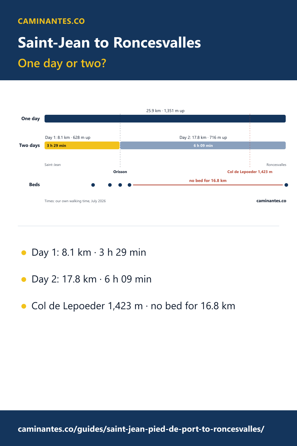
Split, the first day is 8.1 km: about half of the shortest stage anywhere else on our Francés plan (16.1 km). It took us 3 h 29 min of walking, and the second day 6 h 09 min. The mountain does not get smaller. Day two still crosses the pass at 1,423 m, and its last 16.8 km have no bed at all. What changes is where your evening falls.
Know these words before your Camino. Spanish is preparation, the same as boots and stages. Try the free topic
It does not skip the Pyrenees
This is the fair objection, and it is worth saying plainly: splitting the stage removes none of the walking. You still cross Lepoeder on day two, still climb 716 m to 1,423 m, still take the whole descent into Roncesvalles. The only difference is that you arrive at the top of it on legs that have had a short day and a night's sleep instead of seven hours and a mountain.
Book it the day you book your flight
The catch is supply. There are four places to sleep on the mountain, and between them they hold 66 beds, against 183 in the pilgrim albergue at Roncesvalles.
| On the climb | From Saint-Jean | Beds | Open |
|---|---|---|---|
| Ferme Ithurburia | 5.2 km | 22 | not recorded |
| Gîte Kayola | 7 km | 12 | Apr 1-Oct 15 |
| Le Refuge Orisson | 8.1 km | 28 | Mar-Oct |
| Auberge Borda | 9.1 km | 4 | not recorded |
Places, bed counts and seasons from OpenStreetMap, read on 28 August 2026 and matched to the route by position rather than by name. Where the map records nothing the table says so, rather than filling the gap with an estimate.
After the last of them there is nothing to book for 16.8 km, all the way to Roncesvalles. That is the real reason to reserve early: not that Orisson is popular, but that on this stage there is no second choice within a day's walk. In the summer months it is gone months ahead.
When the mountain is the wrong plan
The beds up there are seasonal, and so is the route. In bad weather the high crossing is a genuinely serious mountain day rather than a long walk, which is why Caminantes carries the Valcarlos variant: a lower valley alternative that crosses at Ibañeta instead. It is the sensible answer in winter and in a forecast you do not like, and there is no Orisson on it, so the split this page argues for is a fair-weather plan.
Full transcript
You only see these if you stop walking. Saint-Jean-Pied-de-Port to Roncesvalles is the hardest stage on the whole Camino Francés, and most people walk it on their very first day, on legs that have never carried a backpack before. So stop at Orisson instead. It is the most beautiful stretch of the whole route, where you are in by lunchtime with nothing left to do but sit with the view, the wine and the good company of other pilgrims. Here is what the short version cost me: under 9 km, and it still took me three and a half hours to complete. And you have to think about the elevation, because it is not the way up that is the problem, it is the way down, so if you carry on to Roncesvalles you have still got 18 km ahead of you. Now, splitting it does not skip the climb. You still cross the pass on day two, you just do it on the legs that actually work. The catch is that Orisson is a small refuge with a couple of dozen beds, and in the peak season it is booked out months ahead, so book it the day you book your flight. And the app that is used throughout the video is called Caminantes, there is a link to it below. Let me know how you handle the Pyrenees.
The rest of the route is measured the same way: the Camino Francés stage by stage with every day's distance and climb, the full elevation profile, and how the Francés compares with the other nine on total ascent. If the first day has you rethinking the rest, see how many kilometres a day pilgrims really average.
Common questions
How far is Saint-Jean-Pied-de-Port to Roncesvalles?
25.9 km, measured along the route rather than taken from a guidebook, with 1,351 m of climbing and a high point of 1,423 m at Col de Lepoeder. It is the hardest single stage on the Camino Francés, and the great majority of pilgrims walk it as their first day.
How far is Saint-Jean-Pied-de-Port to Orisson?
8.1 km, with 628 m of climbing, all of it uphill on a narrow road. It took me three and a half hours with a full pack, which sounds slow until you look at the gradient. You arrive around lunchtime with the afternoon free.
Do you have to book Orisson in advance?
Yes, and early. OpenStreetMap records 28 beds at Le Refuge Orisson, and there are 66 beds in total on the whole mountain against 183 in the pilgrim albergue at Roncesvalles. In the summer months those beds are spoken for months ahead. Book it the day you book your flight.
Does splitting the first day mean skipping the Pyrenees?
No. The pass is still there on day two: 716 m of climbing to 1,423 m and the entire descent into Roncesvalles. Splitting the stage does not remove any of the walking, it moves the hard half onto legs that have already had one day and one night to adapt.
What happens if Orisson is full?
There are three other places to sleep on the climb, all of them small, and they are listed on this page with the distance from Saint-Jean. After the last of them, at 9.1 km, there is nothing to book for the remaining 16.8 km to Roncesvalles. If none of them has a bed, walking the whole stage or taking the valley route through Valcarlos are the two honest options.
Keep reading
The eighty Spanish words a Camino actually runs on
Asking for a bed, the credencial stamp, the pilgrim menu, and saying where it hurts. The words that matter on the trail, and none of the ones that do not.
The steepest Camino is not the one with the most climbing
Elevation gain for all ten routes, measured from the tracks and ranked by climb per kilometre rather than by total, which changes the order more than you would think.
How to get the Compostela, including the exception nobody explains
The last 100 km, two stamps a day, and the A Coruña rule that trips people up. What the certificate is, what it is not, and the second document you have to ask for.
Take it with you
Caminantes is free, works offline, and plans your stages around your own legs rather than a guidebook's.