Caminantes
The Camino Portugués coastal route against the central: 23.2 km longer, 246 m less climbing
By August Frederik Kramer · Last updated 28 September 2026
From Porto, the Camino Portugués coastal route is 269.6 km to Santiago, in 12 stages on our plan. The central route is 246.4 km, in 13. So the coast is 23.2 km longer, about one more day of walking, and it still climbs 246 m less, because for most of its length it barely leaves the sea.
Every guide describes the two routes. We measured them, the same way, from the same city to the same cathedral: distance, climbing, days, places to sleep and pilgrims. Here is the whole comparison, and the figure that surprised us most: in 2016 one Portugués pilgrim in twenty took the coast, and in 2025 it was 47%.
Two routes, one map
The coast (blue) follows the Atlantic north through Vila do Conde, Viana do Castelo and Baiona, crosses the Minho by ferry from Caminha to A Guarda, and turns inland at Vigo. The central route (grey) goes through Barcelos, Ponte de Lima and Valença. They meet at Redondela, and the last 85.3 km to Santiago are one path (dark blue).
- Coastal route
- Central route
- Both, from Redondela
- Ferry over the Minho, not walked
Download the poster (PNG)1000 × 1500 px, free to share with a link back.
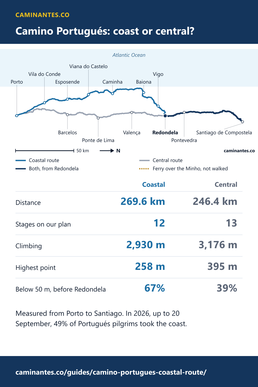
Coast against central, from Porto
Both columns start in Porto and end at the cathedral in Santiago, and every figure is measured the same way on both.
| Coastal | Central | |
|---|---|---|
| Distance | 269.6 km | 246.4 km |
| Stages on our plan | 12 | 13 |
| Average day | 22.5 km | 19.0 km |
| Climbing | 2,930 m | 3,176 m |
| Highest point | 258 m | 395 m |
| Below 50 m, before Redondela | 67% | 39% |
| Places to sleep mapped | 195 | 201 |
| Beds | – | – |
| Pilgrims in 2025 | 89,503 | 100,804 |
Beds get a dash on purpose. Only 8% of the coastal places and 21% of the central ones publish a bed count on OpenStreetMap, far too few to add up, so we count places, not beds.
Longer, but flatter
On the coast, 67% of the walking before Redondela is less than 50 m above the sea: 123.9 of 183.8 km. On the central route it is 39%. Until the two join, the coast never gets higher than 174 m, while the central tops out at 395 m on the day from Ponte de Lima to Agualonga.
- Less than 50 m above the sea
The coastal walk does reach 258 m, but only on the last day, from Infesta into Santiago, on the path it shares with the central. The highest ground of the coastal Camino is ground every Portugués pilgrim crosses anyway.
The coastal route in 12 stages
Our plan for the coast, built the same way as for all ten routes: 8 stages of its own to Redondela, then the central route’s last 4 into Santiago. Places to sleep are the ones OpenStreetMap maps within 300 m of the path; the first day counts Porto’s own.
| Day | Stage | Distance | Climbing | Highest | Places to sleep |
|---|---|---|---|---|---|
| 1 | Porto – Vila do Conde | 29.4 km | 287 m | 115 m | 78 |
| 2 | Vila do Conde – Esposende | 24.1 km | 73 m | 23 m | 9 |
| 3 | Esposende – Viana do Castelo | 25.8 km | 282 m | 127 m | 10 |
| 4 | Viana do Castelo – Vila Praia de Âncora | 18.9 km | 203 m | 139 m | 4 |
| 5 | Vila Praia de Âncora – O Arrabal | 25.6 km | 219 m | 82 m | 9 |
| 6 | O Arrabal – Baiona | 18.9 km | 237 m | 107 m | 4 |
| 7 | Baiona – Vigo | 26.6 km | 435 m | 173 m | 2 |
| 8 | Vigo – Redondela | 14.9 km | 111 m | 174 m | 8 |
| 9 | Redondela – Pontevedrashared | 20.3 km | 304 m | 151 m | 11 |
| 10 | Pontevedra – Caldas de Reisshared | 21.1 km | 184 m | 123 m | 12 |
| 11 | Caldas de Reis – Infestashared | 15.6 km | 178 m | 164 m | 10 |
| 12 | Infesta – Santiago de Compostelashared | 28.3 km | 417 m | 258 m | 36 |
Know these words before your Camino. Spanish is preparation, the same as boots and stages. Try the free topic
The 100 km line: Vigo, by a whisker
The Compostela asks for the last 100 km on foot. On our line, Vigo is 100.3 km from Santiago: 0.3 km to spare, closer than any measurement can promise. If the certificate matters to you, start one stage earlier, in Baiona, 126.9 km out.
Walking from Vigo? Vigo to Santiago takes the five days one by one.
Nearly one in two now walk the coast
The Pilgrim’s Office counts the two routes separately. In 2016, 2,600 pilgrims arrived by the coast, 5% of everyone who walked the Portugués. In 2018 it was 13,841; in 2025 it was 89,503, 6.5 times as many, and 47% of the Portugués. This year, up to 20 September, it is 49%.
We have no split for 2021 to 2023, so the chart leaves those years empty rather than guess. The rest is clear enough: in ten years the coast has gone from a side road to nearly half the route.
The ferry over the Minho
Between Portugal and Spain the coastal route crosses the Minho by boat, from Caminha to A Guarda: 1.6 km in a straight line. It is not walked, so it is in no distance on this page. We publish no timetable, because it changes with the season.
The OpenStreetMap route also holds a branch that follows the river inland to Valença, 31.0 km, and joins the central route at Tui. That is a third way, not the coast, and we do not measure it here.
So which one?
Take the coast for the sea and the flat, and plan one more day for its extra 23.2 km. Take the central for the shorter walk and one real climb, after Ponte de Lima. Places to sleep are level: 195 mapped on the coast, 201 on the central.
Either way, the last 85.3 km from Redondela are the same, and so is the arrival.
The central route stage by stage, and the start from Tui, are in our guide from Porto and Tui. The detour by boat from Pontevedra is the Variante Espiritual, measured.
Walking from Tui? The six days, the places to sleep and the crowds are in Tui to Santiago, day by day.
How we measured it
The coastal line is two OpenStreetMap route relations, 6100606 in Portugal and 12786089 in Galicia, fetched on 28 September 2026 and joined across gaps of 16, 25, 17, 8 m and across the ferry. It meets the central route 7 m apart at Redondela. Heights are SRTM 30 m, one sample every 100 m, the same as for all ten routes; places to sleep are OpenStreetMap lodging within 300 m of the line. Map data © OpenStreetMap contributors, ODbL.
The Camino Portugués route page
Common questions
How long is the Camino Portugués coastal route from Porto?
269.6 km to Santiago, in 12 stages on our plan, an average of 22.5 km a day. The central route from Porto is 246.4 km.
Is the coastal route easier than the central?
Flatter, not shorter. It climbs 2,930 m against 3,176 m and stays below 174 m until Redondela, but it is 23.2 km longer, about one more day.
Where do the coastal and central routes meet?
At Redondela, 85.3 km before Santiago. From there they are one path.
How many pilgrims walk the coastal route?
89,503 in 2025, 47% of everyone who walked the Camino Portugués, up from 5% in 2016.
Keep reading
Camino Francés stages: all 36, and 2 in 3 walk only 5
Every stage drawn at one scale, the body-mind-soul saying tested, and the hardest day by an 1892 formula. Day 1 walks like 37.2 km.
Camino albergues: 584 places on the Francés, and where the gaps are
There is no shortage of beds. One Galician stage has 40 places on it and one meseta stage has 3, and the longest gap with nothing mapped falls on day one.
Which Camino is hardest? The ten ranked by climb per km
The steepest route is also the shortest, and the longest is only eighth steepest. All ten measured on both axes, from their own GPS tracks.
Take it with you
Caminantes is free, works offline, and plans your stages around your own legs rather than a guidebook's.