Caminantes
The 36 stages of the Camino Francés, drawn to scale
By August Frederik Kramer · Last updated 27 September 2026
The Camino Francés is 768.6 km in 36 stages, and the average stage is 21.4 km: a half marathon, with a backpack, every day for five weeks. That is the least interesting thing about it. Day 1 climbs more than four Eiffel Towers. Day 21 climbs 17 m, less than a 6-storey building. And of the 241,998 people who finished the Francés in 2025, two in three walked only the last 5 stages.
The whole route on one line
Here is the Francés drawn like a metro map. Distances along each row are to scale, and the colours are the three parts pilgrims have always divided it into. The line is as thick as the number of people on it.
Download this map as a poster (PNG)Free to use on your blog, in your group or in your pilgrim journal. A link back to this page is all we ask.
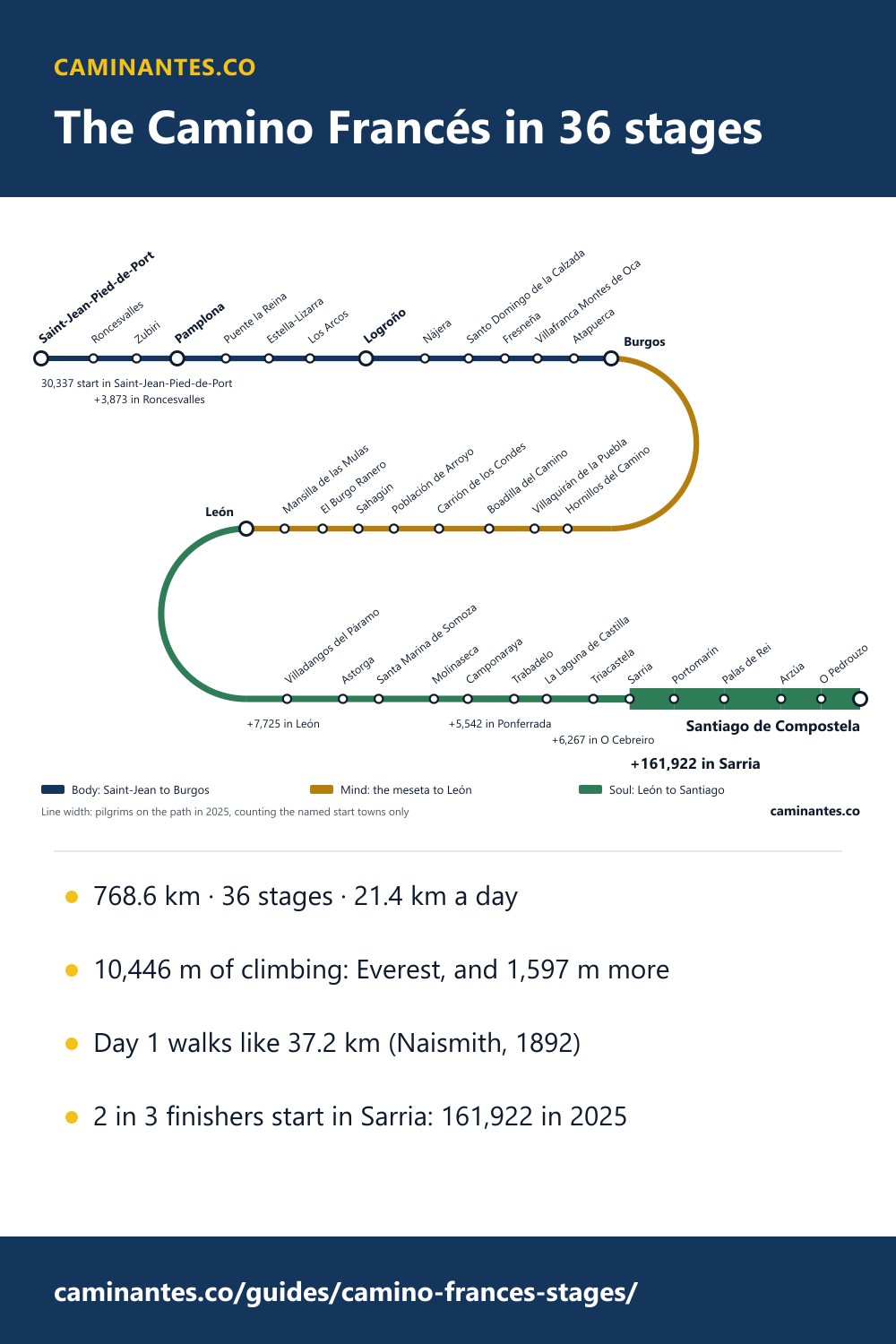
It starts thin: 30,337 people set out from Saint-Jean-Pied-de-Port in 2025. A few thousand more join in León, Ponferrada and O Cebreiro, and for four weeks the line only grows slowly. Then it reaches Sarria and becomes 4 times as thick overnight, because 161,922 people start there. If the last week of your Camino felt like a different walk, this is why.
Body, mind, soul: does the old saying hold?
Ask anyone who has walked it and you will hear the Francés has three parts. The body is Saint-Jean to Burgos, where your legs complain. The mind is the meseta, Burgos to León, flat and endless, where your head does the work. The soul is León to Santiago, where it all starts to mean something. It is a nice story. Here it is, measured.
- Body: Saint-Jean to Burgos
- Mind: the meseta to León
- Soul: León to Santiago
- Distance
- 37%Body: Saint-Jean to Burgos: 37%23%Mind: the meseta to León: 23%40%Soul: León to Santiago: 40%
- Climbing
- 47%Body: Saint-Jean to Burgos: 47%10%Mind: the meseta to León: 10%43%Soul: León to Santiago: 43%
- Places to sleep
- 30%Body: Saint-Jean to Burgos: 30%19%Mind: the meseta to León: 19%51%Soul: León to Santiago: 51%
Stage plan and climbing from the route’s GPS track, places to sleep from OpenStreetMap · caminantes.co
The body is real. 13 days and 282.9 km, 37% of the distance, and 47% of all the climbing on the route: 17.2 m of ascent for every kilometre.
The mind is the part the saying gets exactly right. The meseta is 23% of the walk and only 10% of the climbing, 5.9 m per kilometre. For 9 days the ground hardly moves, and there is nothing to do but think.
The soul is where the saying misleads. It sounds gentle. It is not: León to Santiago holds 43% of the climbing, almost as much as the body, with the route’s highest point (1,505 m) and the climb to O Cebreiro both in it. And it is where the people are, as the line map above shows.
Know these words before your Camino. Spanish is preparation, the same as boots and stages. Try the free topic
Every day, drawn at the same scale
Most stage profiles are drawn so every day fills its box, which makes a stroll look like an Alp. These are all drawn on one scale: the same height from the route’s lowest ground to its highest, the same width for the same kilometres. Look at the shapes before you read the numbers. Altogether the Francés climbs 10,446 m, which is Everest from sea level and then another 1,597 m, and it does not climb it evenly.
Day 125.9 km
Saint-Jean-Pied-de-Port → Roncesvalles
↑ 1,351 m ↓ 584 m
Steepest
Day 221.3 km
Roncesvalles → Zubiri
↑ 263 m ↓ 668 m
Day 320.2 km
Zubiri → Pamplona
↑ 187 m ↓ 265 m
Day 424.1 km
Pamplona → Puente la Reina
↑ 394 m ↓ 504 m
Day 521.3 km
Puente la Reina → Estella-Lizarra
↑ 341 m ↓ 268 m
Day 620.5 km
Estella-Lizarra → Los Arcos
↑ 339 m ↓ 311 m
Day 727.8 km
Los Arcos → Logroño
↑ 342 m ↓ 418 m
Day 829.3 km
Logroño → Nájera
↑ 376 m ↓ 265 m
Longest
Day 921.7 km
Nájera → Santo Domingo de la Calzada
↑ 370 m ↓ 223 m
Day 1018.1 km
Santo Domingo de la Calzada → Fresneña
↑ 291 m ↓ 142 m
Day 1116.1 km
Fresneña → Villafranca Montes de Oca
↑ 241 m ↓ 75 m
Shortest
Day 1218.2 km
Villafranca Montes de Oca → Atapuerca
↑ 245 m ↓ 251 m
Day 1318.4 km
Atapuerca → Burgos
↑ 117 m ↓ 209 m
Day 1421.8 km
Burgos → Hornillos del Camino
↑ 121 m ↓ 159 m
Day 1516.4 km
Hornillos del Camino → Villaquirán de la Puebla
↑ 153 m ↓ 180 m
Day 1622.5 km
Villaquirán de la Puebla → Boadilla del Camino
↑ 241 m ↓ 259 m
Day 1724.8 km
Boadilla del Camino → Carrión de los Condes
↑ 102 m ↓ 50 m
Day 1822.4 km
Carrión de los Condes → Población de Arroyo
↑ 94 m ↓ 50 m
Day 1917.6 km
Población de Arroyo → Sahagún
↑ 105 m ↓ 159 m
Day 2017.7 km
Sahagún → El Burgo Ranero
↑ 96 m ↓ 29 m
Day 2118.9 km
El Burgo Ranero → Mansilla de las Mulas
↑ 17 m ↓ 101 m
Flattest
Day 2219.0 km
Mansilla de las Mulas → León
↑ 137 m ↓ 96 m
Day 2320.2 km
León → Villadangos del Páramo
↑ 156 m ↓ 105 m
Day 2427.6 km
Villadangos del Páramo → Astorga
↑ 152 m ↓ 176 m
Day 2517.8 km
Astorga → Santa Marina de Somoza
↑ 233 m ↓ 21 m
Day 2627.4 km
Santa Marina de Somoza → Molinaseca
↑ 487 m ↓ 982 m
Knee day
Day 2716.8 km
Molinaseca → Camponaraya
↑ 89 m ↓ 176 m
Day 2823.0 km
Camponaraya → Trabadelo
↑ 289 m ↓ 207 m
Day 2916.1 km
Trabadelo → La Laguna de Castilla
↑ 616 m ↓ 34 m
Day 3023.2 km
La Laguna de Castilla → Triacastela
↑ 371 m ↓ 850 m
Day 3118.0 km
Triacastela → Sarria
↑ 274 m ↓ 499 m
Day 3222.0 km
Sarria → Portomarín
↑ 339 m ↓ 440 m
Day 3324.9 km
Portomarín → Palas de Rei
↑ 512 m ↓ 318 m
Day 3428.3 km
Palas de Rei → Arzúa
↑ 455 m ↓ 609 m
Day 3519.9 km
Arzúa → O Pedrouzo
↑ 280 m ↓ 379 m
Day 3619.3 km
O Pedrouzo → Santiago de Compostela
↑ 268 m ↓ 289 m
Day 1 is a wall. 1,351 m up in 25.9 km, from Saint-Jean over the Pyrenees to Roncesvalles. That is more than four Eiffel Towers stacked, on your first morning.
Day 21 is a floor. From El Burgo Ranero to Mansilla de las Mulas the path climbs 17 m in 18.9 km, less than a 6-storey building. It is the flattest day on the route and it is in the middle of the meseta.
Day 26 is the one your knees remember. It crosses the highest ground on the Camino, 1,505 m near the Cruz de Ferro, then drops 982 m into Molinaseca: almost three Eiffel Towers, downhill. Pilgrims worry about the climbs; the descents are what break toenails.
The hardest day, by a formula from 1892
In 1892 a Scottish mountaineer, William Naismith, wrote down a rule that walkers still use: allow an hour for every 5 km, plus an hour for every 600 m of climbing. Which means 600 m of up is worth 5 km of flat. Add the climbing to the distance that way and every stage gets an honest length: how far it walks, not how far it is.
By that measure day 1 is not 25.9 km. It walks like 37.2 km, which makes it the hardest day on the Francés by a distance, harder than day 8, the longest stage on paper at 29.3 km. The five hardest days:
- Day 1, Saint-Jean-Pied-de-Port to Roncesvalles: 25.9 km that walk like 37.2 km
- Day 8, Logroño to Nájera: 29.3 km that walk like 32.4 km
- Day 34, Palas de Rei to Arzúa: 28.3 km that walk like 32.1 km
- Day 26, Santa Marina de Somoza to Molinaseca: 27.4 km that walk like 31.5 km
- Day 7, Los Arcos to Logroño: 27.8 km that walk like 30.7 km
Naismith was writing for fit Victorian gentlemen on Scottish hills, so read his hours as a comparison, not a timetable. What the rule is good at is ranking, and the ranking is the useful part: it tells you which evenings to plan short.
The five days two in three people walk
The Pilgrim’s Office counted 241,998 people arriving in Santiago on the Francés in 2025. 161,922 of them started in Sarria: 67%, two in three. For every pilgrim who started in Saint-Jean, 5.3 started in Sarria. The reason is the rule: the Compostela asks for the last 100 km on foot, and Sarria sits just outside it, 114.4 km out, with a railway station.
Here is the part nobody mentions. Those 5 stages are 114.4 km, 15% of the route, and they hold 18% of its climbing: 1,854 m, more than all 9 days of the meseta put together (1,066 m). Galicia rolls. If you are walking from Sarria, you are not doing the easy bit of the Camino. You are doing the busiest bit, and a hilly one.
The busiest bit has the beds to match: the last 100 km has 140 places to sleep, 1.4 per kilometre against 0.8 on the route as a whole. If you are coming for the full five weeks instead, where you start the Francés changes the climbing more than you would think.
The five days from Sarria as a trip of their own, with where to sleep and when it is busiest: Sarria to Santiago.
All 36 stages
Every stage with its distance, climbing, descent, Naismith length and the number of places to sleep along it. The stage ends are generated from the route itself rather than copied from a guidebook, so they will not match every book, and they are a starting point, not an instruction. The Camino Francés route page has the same plan with the app to walk it.
| Day | Stage | km | Up (m) | Down (m) | Walks like (km) | Places to sleep |
|---|---|---|---|---|---|---|
| 1 | Saint-Jean-Pied-de-Port → Orreaga / Roncesvalles | 25.9 | 1,351 | 584 | 37.2 | 24 |
| 2 | Orreaga / Roncesvalles → Zubiri | 21.3 | 263 | 668 | 23.5 | 18 |
| 3 | Zubiri → Pamplona / Iruña | 20.2 | 187 | 265 | 21.8 | 17 |
| 4 | Pamplona / Iruña → Puente la Reina / Gares | 24.1 | 394 | 504 | 27.4 | 10 |
| 5 | Puente la Reina / Gares → Estella-Lizarra | 21.3 | 341 | 268 | 24.1 | 7 |
| 6 | Estella-Lizarra → Los Arcos | 20.5 | 339 | 311 | 23.3 | 5 |
| 7 | Los Arcos → Logroño | 27.8 | 342 | 418 | 30.7 | 18 |
| 8 | Logroño → Nájera | 29.3 | 376 | 265 | 32.4 | 25 |
| 9 | Nájera → Santo Domingo de la Calzada | 21.7 | 370 | 223 | 24.8 | 6 |
| 10 | Santo Domingo de la Calzada → Fresneña | 18.1 | 291 | 142 | 20.5 | 12 |
| 11 | Fresneña → Villafranca Montes de Oca | 16.1 | 241 | 75 | 18.1 | 14 |
| 12 | Villafranca Montes de Oca → Atapuerca | 18.2 | 245 | 251 | 20.2 | 8 |
| 13 | Atapuerca → Burgos | 18.4 | 117 | 209 | 19.4 | 6 |
| 14 | Burgos → Hornillos del Camino | 21.8 | 121 | 159 | 22.8 | 20 |
| 15 | Hornillos del Camino → Villaquirán de la Puebla | 16.4 | 153 | 180 | 17.7 | 6 |
| 16 | Villaquirán de la Puebla → Boadilla del Camino | 22.5 | 241 | 259 | 24.5 | 22 |
| 17 | Boadilla del Camino → Carrión de los Condes | 24.8 | 102 | 50 | 25.7 | 18 |
| 18 | Carrión de los Condes → Población de Arroyo | 22.4 | 94 | 50 | 23.2 | 3 |
| 19 | Población de Arroyo → Sahagún | 17.6 | 105 | 159 | 18.5 | 10 |
| 20 | Sahagún → El Burgo Ranero | 17.7 | 96 | 29 | 18.5 | 4 |
| 21 | El Burgo Ranero → Mansilla de las Mulas | 18.9 | 17 | 101 | 19.0 | 12 |
| 22 | Mansilla de las Mulas → León | 19.0 | 137 | 96 | 20.1 | 17 |
| 23 | León → Villadangos del Páramo | 20.2 | 156 | 105 | 21.5 | 6 |
| 24 | Villadangos del Páramo → Astorga | 27.6 | 152 | 176 | 28.9 | 8 |
| 25 | Astorga → Santa Marina de Somoza | 17.8 | 233 | 21 | 19.7 | 12 |
| 26 | Santa Marina de Somoza → Molinaseca | 27.4 | 487 | 982 | 31.5 | 16 |
| 27 | Molinaseca → Camponaraya | 16.8 | 89 | 176 | 17.5 | 10 |
| 28 | Camponaraya → Trabadelo | 23.0 | 289 | 207 | 25.4 | 16 |
| 29 | Trabadelo → La Laguna de Castilla | 16.1 | 616 | 34 | 21.2 | 23 |
| 30 | La Laguna de Castilla → Triacastela | 23.2 | 371 | 850 | 26.3 | 12 |
| 31 | Triacastela → Sarria | 18.0 | 274 | 499 | 20.3 | 36 |
| 32 | Sarria → Portomarín | 22.0 | 339 | 440 | 24.8 | 25 |
| 33 | Portomarín → Palas de Rei | 24.9 | 512 | 318 | 29.2 | 40 |
| 34 | Palas de Rei → Arzúa | 28.3 | 455 | 609 | 32.1 | 31 |
| 35 | Arzúa → O Pedrouzo | 19.9 | 280 | 379 | 22.2 | 27 |
| 36 | O Pedrouzo → Santiago de Compostela | 19.3 | 268 | 289 | 21.5 | 32 |
Places to sleep: albergues, guest houses and refuges within 300 m of the track, from OpenStreetMap. Hotels are not counted.
Where the numbers come from
Distances and climbing are measured from the route’s own GPS track, sampled every 100 m against the SRTM elevation model, with rises under 3 m ignored so that sensor noise does not turn into imaginary hills. Places to sleep are from OpenStreetMap, the same snapshot as our map of where the beds are.
The crowd is the Pilgrim’s Office count for 2025, by the town people said they started in. The office names its twenty biggest start towns and six of them are on the Francés. The other 26,332 Francés pilgrims started in towns too small to make the list, each under 3,646, so the line on the map is a floor: the real line is a little thicker, and nowhere near thick enough to change the story at Sarria.
The comparisons use a half marathon of 21.1 km, Everest at 8,849 m, the Eiffel Tower at 330 m and a storey at 3 m. Every figure on this page is computed from those files when the site is built, not typed in.
Common questions
How many stages is the Camino Francés?
On our plan, 36 stages over 768.6 km from Saint-Jean-Pied-de-Port to Santiago, averaging 21.4 km a day. Other plans split it differently; the number depends on where you choose to sleep, not on the route.
What is the hardest stage of the Camino Francés?
Day 1, Saint-Jean-Pied-de-Port to Roncesvalles: 1,351 m of climbing in 25.9 km. By Naismith’s rule it walks like 37.2 km, more than any other day, including the longest stage on paper (day 8, 29.3 km).
What is the longest stage of the Camino Francés?
Day 8, Logroño to Nájera, at 29.3 km on our plan. The shortest is day 11 into Villafranca Montes de Oca, at 16.1 km.
How many stages are there from Sarria?
5 stages and 114.4 km, which is what two in three Francés pilgrims walk: 161,922 of 241,998 in 2025. They are not flat. They climb 1,854 m, more than the whole meseta.
Is the meseta really flat?
Yes, measurably. Burgos to León is 23% of the route and 10% of its climbing, 5.9 m per kilometre against 17.2 in the first part. The flattest day on the route, day 21, climbs 17 m.
Keep reading
Camino albergues: 584 places on the Francés, and where the gaps are
There is no shortage of beds. One Galician stage has 40 places on it and one meseta stage has 3, and the longest gap with nothing mapped falls on day one.
Which Camino is hardest? The ten ranked by climb per km
The steepest route is also the shortest, and the longest is only eighth steepest. All ten measured on both axes, from their own GPS tracks.
What does Buen Camino mean, and how do you reply?
Word for word it is "good path". What it actually does, how to answer it, who says it, and the fifteen other words you will hear every day.
Take it with you
Caminantes is free, works offline, and plans your stages around your own legs rather than a guidebook's.