Caminantes
Monte do Gozo: the Hill of Joy, and the last 5.0 km to the cathedral
By August Frederik Kramer · Last updated 13 October 2026
10.4km to go
302m above the sea
Lavacolla, 302 m. 10.4 km to go, and one last climb ahead.
You made it. From the Hill of Joy it was 5.0 km, and you came down 97 m to the square, 94 m of it in the first 1.5 km.
Next, the arrival itself, step by step: the cathedral.
Tap the button to walk to the next stop. On the hill, look for the spires.
- Lavacolla10.4 km to go, 302 m
- Top of the last climb7.6 km to go, 390 m
- Monte do Gozo5.0 km to go, 369 m
- San Lázaro3.5 km to go, 275 m
- Porta do Camiño0.5 km to go, 273 m
- Praza do Obradoiro0.0 km to go, 272 m
Download the poster (PNG)Free to print and share. Please keep caminantes.co on it.
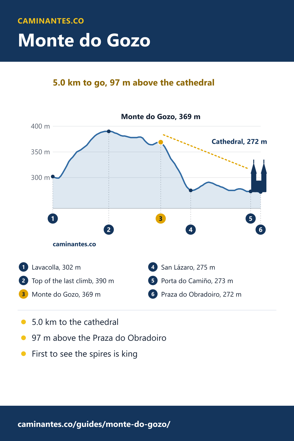
Monte do Gozo is where pilgrims on the Camino Francés first saw the spires of Santiago. On our measured track the chapel of San Marcos, on the hill, is 5.0 km from the Praza do Obradoiro, and you stand 97 m above the square. Almost all of that height goes in the next 1.5 km.
What Monte do Gozo is
Monte do Gozo, the Hill of Joy, is the last hill on the Camino Francés before Santiago. It is named for the joy of the pilgrims who saw the cathedral’s spires from here for the first time. Its old Galician name, Monxoi, comes from the French Montjoie. Archbishop Diego Gelmírez had a chapel built on the hill in 1105; it was abandoned in the 17th century. Today the small chapel of San Marcos stands beside the path.
Run for the spires
An old custom: pilgrims walking together raced up the last stretch, and the first to see the towers was hailed as king of the group. Some guides say the surnames Rey, Roy and Leroy began here; nobody has shown it. The race, if your legs agree, starts at Lavacolla: it is the last real climb of the Camino, 88 m up to 390 m.
What you find there today
The large monument on the summit, put up for John Paul II’s visit and World Youth Day in 1989, was taken away in 2021. What remains is quieter: two statues of pilgrims by the sculptor José María Acuña, looking towards the city, about 350 m off the path, and a viewpoint over Santiago about 100 m from it. From the path itself trees hide much of the view, so for your first sight of the spires, take the short detour.
How far it is: 5.0 km
On our track the chapel of San Marcos is 5.0 km from the Praza do Obradoiro, 14.3 km into the last day of our plan, day 36, 19.3 km from O Pedrouzo. You stand at 369 m; the square in front of the cathedral is at 272 m, so the cathedral is 97 m below you. The hill is not the day’s highest point: the path tops out at 390 m, 2.6 km earlier, at the end of the climb from Lavacolla.
The walk down into Santiago
From the hill the path drops 94 m in 1.5 km to San Lázaro, 97% of the way down to the square. The last 3.5 km run through the streets of the city. You enter the old town by the Porta do Camiño, 0.5 km from the end, and come down into the Praza do Obradoiro.
What to do when you arrive, step by step: Santiago Cathedral.
The two days in, counted down from the start: Arzúa to Santiago.
The whole last morning from the start, timed: O Pedrouzo to Santiago.
And once you are in: what to see in Santiago after you arrive.
Know these words before your Camino. Spanish is preparation, the same as boots and stages. Try the free topic
Sleeping on the hill
Many pilgrims stop here for the night. The pilgrim complex on the hill, first built for the Holy Year of 1993, has several hundred beds, and from it Santiago is an easy 5.0 km in the morning, in time for the Pilgrim’s Mass. Next to it is an open-air auditorium for large concerts, where the O Son do Camiño festival has been held since 2018.
The last five days, from the start: Sarria to Santiago. Where the last 100 km begin on every route: the last 100 km.
Heights and distances are from our elevation profile of the Camino Francés, sampled every 100 m, with the chapel, the statues, the viewpoint and the gate placed from their OpenStreetMap positions; the waymarks may differ by a few hundred metres. The history and what stands on the hill today are from the Spanish and English Wikipedia articles on Monte do Gozo; the custom of the king from El Debate (April 2025); the statues from viajecaminodesantiago.com.
Common questions
How far is Monte do Gozo from Santiago Cathedral?
5.0 km on foot on our track, from the chapel of San Marcos on the hill to the Praza do Obradoiro, mostly downhill at first.
Can you see the cathedral from Monte do Gozo?
From the viewpoint and the pilgrim statues, a short detour off the path, you can look over the city. From the path itself trees hide much of the view.
Why is it called Monte do Gozo?
It means Hill of Joy: it is where pilgrims first saw the spires of the cathedral. By old custom, the first of a group to see them was hailed as king.
How high is Monte do Gozo?
The path crosses it at 369 m on our track, 97 m above the Praza do Obradoiro. The summit by the statues is a few metres higher.
Can you sleep at Monte do Gozo?
Yes. The pilgrim complex on the hill has several hundred beds, 5.0 km from the cathedral, an easy walk in for the morning.
Keep reading
The bridge at Hospital de Órbigo is 300 m long. The river needs about 20.
Cross it with one button, break a lance with the knight of the Paso Honroso halfway, and see why so much bridge spans so little water.
The Camino from Pamplona: 33 days to Santiago, the Pyrenees already behind you
Day one climbs to the metal pilgrims of the Alto del Perdón. 701.1 km in all, and leaving out the first 3 days saves 9% of the walking but 17% of the climbing.
Santiago Cathedral: what to do when you arrive, in 8 steps
Km 0, the free door in, the hug, the tomb and the Compostela, on a plan you can walk. And this autumn the Pilgrim’s Mass is moving to San Agustín.
Take it with you
Caminantes is free, works offline, and plans your stages around your own legs rather than a guidebook's.