Caminantes
The Camino from Pamplona to Santiago: day by day, over the Alto del Perdón
By August Frederik Kramer · Last updated 13 October 2026
- 0
- km walked
- 701.1
- km to Santiago
- m above the sea
- places to sleep mapped on this day
The Alto del Perdón: “where the path of the wind crosses that of the stars”.
Drag the pilgrim along the profile, or use the slider. Every figure is the day you are on. Watch the top of day one.
Download the poster (PNG)Free to print and share. Please keep caminantes.co on it.
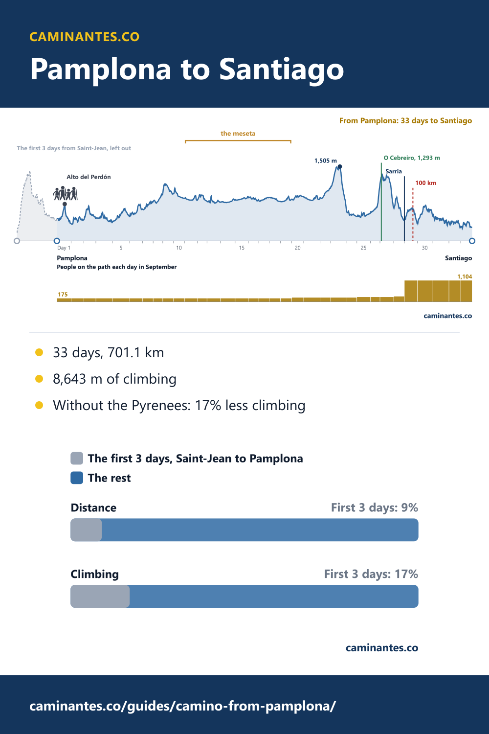
Pamplona is 33 days and 701.1 km from Santiago on our plan, and the walk climbs 8,643 m, just under the height of Everest. Starting here leaves out the first 3 days of the Camino Francés, Saint-Jean over the Pyrenees to Pamplona: 9% of the route’s distance but 17% of its climbing. And the first morning out of the city takes you up to the Alto del Perdón.
Day one: up to the Alto del Perdón
The first day from Pamplona ends in Puente la Reina, and its top comes 13.3 km out of the city: the Alto del Perdón, a ridge of wind turbines at about 770 m. You climb about 370 m to get there. On the top stands a row of pilgrims cut from sheet metal, made by the sculptor Vicente Galbete and put up in 1996, with a line written on it: “where the path of the wind crosses that of the stars”. Then the path drops down the far side, on loose stones, to the villages of Navarra. Wikipedia has the history (in Spanish).
Where day one ends: Puente la Reina, the queen’s bridge, walked in five pictures with the Eunate detour.
What leaving out the first 3 days changes
The first 3 days of the Camino Francés, Saint-Jean to Pamplona, are 67.5 km with 1,801 m of climbing, and 75% of that climbing is day one over the Pyrenees, 1,351 m up. Start in Pamplona and the walk is 9% shorter and has 17% less climbing, and from here it climbs 12.3 m per kilometre, against 13.6 for the route from Saint-Jean. You walk 33 days instead of 36. What you give up is the mountain crossing itself, and the people who set out with you in Saint-Jean.
To walk the last of the mountains but not the climb out of France, start two days earlier: the Camino from Roncesvalles. A week less of walking: the Camino from Logroño.
On the way, the town where a roast cock and hen are said to have crowed: Santo Domingo de la Calzada.
33 days, 21.2 km a day
From Pamplona our plan has 33 days, 21.2 km a day on average. The longest is day 5, Logroño to Nájera, 29.3 km. The steepest is day 26, Trabadelo to La Laguna de Castilla: 616 m up, 38.3 m per kilometre. Over the whole walk you climb 8,643 m, 206 m short of the height of Everest, 8,849 m, climbed from the sea.
Every stage of the Francés from Saint-Jean, one by one: the stages guide.
The way there: Navarra, the Rioja, the meseta, Galicia
After the Perdón the walk crosses Navarra to Estella and reaches Logroño, the capital of the Rioja, at the end of day 4. On day 10 it reaches Burgos. Days 11 to 19, Burgos to León, are the meseta: 181.1 km of high, flat plateau. The route’s high point, 1,505 m, comes on day 23, and O Cebreiro, at 1,293 m and the first village in Galicia, on day 27. On day 29, out of Sarria, you cross the 100 km line that the Compostela asks for.
The meseta, walked from Burgos: Burgos to Santiago. The last big climb, metre by metre: O Cebreiro.
How busy it is: a steady path, then Sarria
The Pilgrim’s Office lists its 20 biggest starting points, and Pamplona is not one of them: fewer than 3,646 people a year start here, the smallest number on that list, which in September would be at most 19 a day. Most people on the path out of Pamplona started in Saint-Jean or Roncesvalles a few days before: about 175 a day in September, a floor, because the starts the office does not name are not in it. From day 29, out of Sarria, it is 1,104: 6.3 times as many.
The last days from Sarria have their own page: Sarria to Santiago.
Know these words before your Camino. Spanish is preparation, the same as boots and stages. Try the free topic
Getting to Pamplona
Pamplona is the capital of Navarra and easy to reach: it has a small airport, a railway station on the line from Madrid, and a bus station with coaches from Madrid, Bilbao and San Sebastián. The Camino enters the old town over the Magdalena bridge and leaves it past the university, so you can start from your door. Check timetables with the operators before you book.
Every day from Pamplona
| Day | Stage | km | m up | Places to sleep | People a day, September |
|---|---|---|---|---|---|
| 1 | Pamplona / Iruña → Puente la Reina / Gares | 24.1 | 394 | 10 | 175 |
| 2 | Puente la Reina / Gares → Estella-Lizarra | 21.3 | 341 | 7 | 175 |
| 3 | Estella-Lizarra → Los Arcos | 20.5 | 339 | 5 | 175 |
| 4 | Los Arcos → Logroño | 27.8 | 342 | 18 | 175 |
| 5 | Logroño → Nájera | 29.3 | 376 | 25 | 175 |
| 6 | Nájera → Santo Domingo de la Calzada | 21.7 | 370 | 6 | 175 |
| 7 | Santo Domingo de la Calzada → Fresneña | 18.1 | 291 | 12 | 175 |
| 8 | Fresneña → Villafranca Montes de Oca | 16.1 | 241 | 14 | 175 |
| 9 | Villafranca Montes de Oca → Atapuerca | 18.2 | 245 | 8 | 175 |
| 10 | Atapuerca → Burgos | 18.4 | 117 | 6 | 175 |
| 11 | Burgos → Hornillos del Camino | 21.8 | 121 | 20 | 175 |
| 12 | Hornillos del Camino → Villaquirán de la Puebla | 16.4 | 153 | 6 | 175 |
| 13 | Villaquirán de la Puebla → Boadilla del Camino | 22.5 | 241 | 22 | 175 |
| 14 | Boadilla del Camino → Carrión de los Condes | 24.8 | 102 | 18 | 175 |
| 15 | Carrión de los Condes → Población de Arroyo | 22.4 | 94 | 3 | 175 |
| 16 | Población de Arroyo → Sahagún | 17.6 | 105 | 10 | 175 |
| 17 | Sahagún → El Burgo Ranero | 17.7 | 96 | 4 | 175 |
| 18 | El Burgo Ranero → Mansilla de las Mulas | 18.9 | 17 | 12 | 175 |
| 19 | Mansilla de las Mulas → León | 19.0 | 137 | 17 | 175 |
| 20 | León → Villadangos del Páramo | 20.2 | 156 | 6 | 215 |
| 21 | Villadangos del Páramo → Astorga | 27.6 | 152 | 8 | 215 |
| 22 | Astorga → Santa Marina de Somoza | 17.8 | 233 | 12 | 215 |
| 23 | Santa Marina de Somoza → Molinaseca | 27.4 | 487 | 16 | 215 |
| 24 | Molinaseca → Camponaraya | 16.8 | 89 | 10 | 215 |
| 25 | Camponaraya → Trabadelo | 23.0 | 289 | 16 | 243 |
| 26 | Trabadelo → La Laguna de Castilla | 16.1 | 616 | 23 | 243 |
| 27 | La Laguna de Castilla → Triacastela | 23.2 | 371 | 12 | 243 |
| 28 | Triacastela → Sarria | 18.0 | 274 | 36 | 275 |
| 29 | Sarria → Portomarín | 22.0 | 339 | 25 | 1,104 |
| 30 | Portomarín → Palas de Rei | 24.9 | 512 | 40 | 1,104 |
| 31 | Palas de Rei → Arzúa | 28.3 | 455 | 31 | 1,104 |
| 32 | Arzúa → O Pedrouzo | 19.9 | 280 | 27 | 1,104 |
| 33 | O Pedrouzo → Santiago | 19.3 | 268 | 32 | 1,104 |
Distances and climbing from our own track and stage plan, the same figures as the guide to where to start and the route page. Places to sleep from map data, so read them as places, not beds. People a day: the Pilgrim’s Office’s 2025 starts, spread over the months the way all Compostelas were.
Common questions
How long is the Camino from Pamplona to Santiago?
701.1 km in 33 days on our plan, 21.2 km a day on average, with 8,643 m of climbing.
What do I miss by starting in Pamplona?
The first 3 days from Saint-Jean: 67.5 km and 1,801 m of climbing, most of it the Pyrenees on day one. From Pamplona the walk climbs 12.3 m per kilometre, against 13.6 from Saint-Jean.
How far is the Alto del Perdón from Pamplona?
About 13.3 km on our track, on the first day to Puente la Reina, with about 370 m of climbing to the top.
Do I get the Compostela if I start in Pamplona?
Yes. The Compostela asks for the last 100 km on foot, and the walk from Pamplona is 701.1 km. You cross the 100 km line on day 29, out of Sarria.
Keep reading
Santiago Cathedral: what to do when you arrive, in 8 steps
Km 0, the free door in, the hug, the tomb and the Compostela, on a plan you can walk. And this autumn the Pilgrim’s Mass is moving to San Agustín.
The Cruz de Ferro is not the top of the Camino
Leave your stone at 1,494 m, then keep climbing: the Camino Francés tops out at 1,505 m, 5.5 km later. Walk it from Astorga to Molinaseca.
Baiona to Santiago: 6 days, 126.9 km, and 26.9 km to spare
The coastal Camino Portugués from Baiona, day by day: 363 people a day out of Baiona, 458 from Vigo, then 975 from Redondela.
Take it with you
Caminantes is free, works offline, and plans your stages around your own legs rather than a guidebook's.