Caminantes
The Cruz de Ferro: where it is on the Camino, and why it is not the top
By August Frederik Kramer · Last updated 12 October 2026
873m above the sea
0.0km from Astorga
Astorga, 873 m. Your stone from home is in your pack. The cross is 27.9 km away.
You walked it. From Astorga you rose 621 m to the cross and left your stone. The real top came 5.5 km later, 11 m higher. Then you came down 923 m in 11.8 km to Molinaseca.
Tap the button to walk to the next stop. At the cross, leave your stone.
- Astorga0.0 km, 873 m
- Rabanal del Camino20.5 km, 1,151 m
- Foncebadón25.9 km, 1,427 m
- Cruz de Ferro27.9 km, 1,494 m
- Manjarín30.3 km, 1,439 m
- The top33.4 km, 1,505 m
- El Acebo37.1 km, 1,150 m
- Molinaseca45.2 km, 582 m
Download the poster (PNG)Free to print and share. Please keep caminantes.co on it.
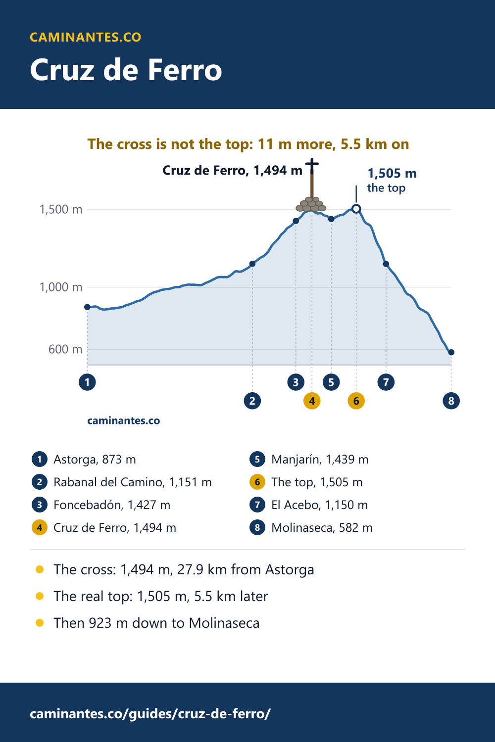
The Cruz de Ferro is called the top of the Camino Francés. On our measured track it is not. The cross stands at 1,494 m, 27.9 km from Astorga, and the path keeps climbing for another 5.5 km, past Manjarín, to 1,505 m. Then it falls 923 m in 11.8 km to Molinaseca.
What the Cruz de Ferro is
An iron cross on a wooden pole about five metres tall, on Monte Irago in the Montes de León, with a mound of stones around its foot. The cross on the pole is a replica: the original is kept in the Museo de los Caminos in Astorga. The small chapel beside it, dedicated to Santiago, was built in 1982.
The stone you carry
The custom is to bring a stone from home and leave it at the foot of the cross. Many pilgrims treat it as something they put down: a worry, a loss, a wish for someone else. In the old form of the custom you throw it with your back to the cross. Bring a small one: it rides in your pack for 27.9 km from Astorga, and for weeks if you start in Saint-Jean.
Where it is: day 2 from Astorga
The cross is 27.9 km from Astorga, on day 2 of the 12 days our plan gives from there to Santiago, 10.1 km into the day from Santa Marina de Somoza. The last village below it is Foncebadón, 2.0 km before the cross and 67 m lower. From Rabanal del Camino, a common place to sleep the night before, it is 7.5 km.
Where most people sleep the night before, and why: Rabanal del Camino, measured.
It is not the top
Past the cross the path dips to Manjarín, 2.3 km on, and climbs again. The highest point of the whole Camino Francés on our track is 1,505 m, 5.5 km after the cross and 11 m above it. The difference is small in metres and real on the ground: when you have left your stone, you are not done climbing.
Then the long way down
From the top to Molinaseca you lose 923 m in 11.8 km, 78.2 m for every kilometre. The way up from Astorga rose 22.3 m a kilometre on average, so the way down is 3.5 times as steep. Day 2 goes down 982 m in all, more than any other day from Astorga. Poles help, and so do short steps.
The whole walk from Astorga, all 12 days: the Camino from Astorga.
Starting after the descent: the Camino from Ponferrada.
Know these words before your Camino. Spanish is preparation, the same as boots and stages. Try the free topic
Planning the day
Sleep in Rabanal del Camino or Foncebadón the night before, and the cross is 7.5 or 2.0 km away in the morning, with the whole descent still ahead. Up here the weather turns quickly: carry a warm layer even in summer, and in winter expect fog, wind and sometimes snow.
What to expect month by month: Camino weather. Every stage of the Francés, one by one: the stages guide.
Heights and distances are from our elevation profile of the Camino Francés, sampled every 100 m, with the cross placed from its OpenStreetMap position; a map may print a few metres more or less. The pole, the replica, the chapel and the custom are from the Spanish Wikipedia article on the Cruz de Ferro.
Common questions
How high is the Cruz de Ferro?
1,494 m on our measured track. The Camino keeps climbing after it, to 1,505 m, 5.5 km further on.
Is the Cruz de Ferro the highest point of the Camino Francés?
Nearly, but not quite. On our track the highest point is 1,505 m, 5.5 km after the cross, past Manjarín, and 11 m higher.
How far is the Cruz de Ferro from Astorga?
27.9 km on foot, through Rabanal del Camino and Foncebadón. On our plan it comes on day 2 from Astorga.
What do you leave at the Cruz de Ferro?
A stone, by custom one brought from home, left at the foot of the cross. Bring a small one: you carry it a long way.
How steep is the way down to Molinaseca?
From the top you lose 923 m in 11.8 km to Molinaseca, 3.5 times as steep as the climb from Astorga. Take it slowly.
Keep reading
Baiona to Santiago: 6 days, 126.9 km, and 26.9 km to spare
The coastal Camino Portugués from Baiona, day by day: 363 people a day out of Baiona, 458 from Vigo, then 975 from Redondela.
The Camino from Astorga: 12 days, 256.7 km, over the Cruz de Ferro
The Camino Francés from Astorga, measured day by day. Day 2 climbs to 1,505 m near the Cruz de Ferro, then drops 982 m to Molinaseca.
The Camino from Logroño: 29 days, 607.4 km, from the Rioja
The Camino Francés from the capital of the Rioja, measured day by day. Leaving out the first week saves 21% of the distance and 31% of the climbing.
Take it with you
Caminantes is free, works offline, and plans your stages around your own legs rather than a guidebook's.