Caminantes
Estella and the Irache wine fountain
By August Frederik Kramer · Last updated 21 October 2026
Puente la Reina. First light on the Arga. You cross the queen’s bridge out of town and head west, into the hills.
Cirauqui. The village sits on top of its hill, 7.3 km out. The last pull is 42 m up from Mañeru, through an arch and over the top; 179 m climbed so far.
Villatuerta. Vineyards and olive groves, 17.5 km out. On the skyline ahead stands the cone of Montejurra, the mountain behind Estella.
Estella. The end of the day: 21.3 km and 341 m of climbing. The steep Puente de la Cárcel takes you over the Ega into the old town.
The wine fountain. The next morning, 2.5 km on and 89 m up: the wall of Bodegas Irache, with two taps, one for water and one for wine.
21.3km from Puente la Reina
341m climbed
Day done: 21.3 km and 341 m of climbing to Estella. Day 5 from Saint-Jean, 655.6 km left to Santiago, and the wine fountain 2.5 km into the next day.
Download the poster (PNG)Free to print and share. Please keep caminantes.co on it.
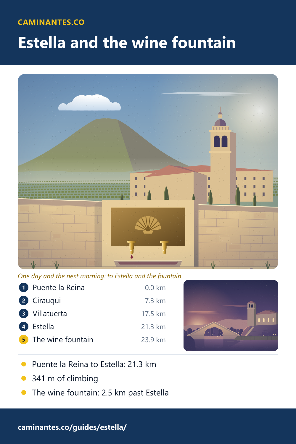
Estella is where the day out of Puente la Reina ends: 21.3 km with 341 m of climbing, through Cirauqui on its hill and the vineyards of Navarre. The next morning, 2.5 km past the town, a wall of the Irache winery pours red wine for pilgrims, free, beside a tap of water. 655.6 km to go.
The wine fountain at Irache
Past Ayegui, 1.3 km out of Estella, the Camino runs along the wall of Bodegas Irache, and set in the wall is the Fuente del Vino: two taps, one of water and one of red wine, free for pilgrims. It comes 2.5 km after the end of our day in Estella, with 89 m of climbing, so most people reach it early in the morning. The winery says it fills the fountain with about 100 litres of young red wine every day, first thing in the morning, and that close to two hundred thousand people stop at it each year. The fountain was set up formally at the end of the 1990s and has a webcam. It carries on an old custom: the monks of Irache met the pilgrims who came to their hospital with a glass of wine.
The monastery of Irache
Behind the wall stands the monastery of Santa María la Real de Irache, a Benedictine house first recorded in 958, which already kept a hospital for pilgrims in the 11th century. Its church was begun in the 12th century and is Romanesque at its east end; the plain square tower with its small dome is 17th century, in the Herrerian style. From 1569 the monastery was also a university. The buildings have stood empty since 1985, though Mass is still said in the church on Sundays.
Estella, “Estella la bella”
Estella was founded around 1090 by King Sancho Ramírez on a bend of the river Ega. The 12th-century guide for pilgrims, written by Aymeric Picaud, praised it as fertile in good bread and excellent wine. Its nickname, Estella la bella, is said to come from the way the town hides among its hills until you are in it. The Palace of the Kings of Navarre, from the 12th century, is the only Romanesque civil building in Navarre, and across the Ega the church of San Pedro de la Rúa stands on its rock above a long stair. The way into the old town crosses the Puente de la Cárcel, a steep, peaked bridge also called the Puente Picudo. In Basque the town is Lizarra.
Cirauqui and the old road
Cirauqui comes 7.3 km out of Puente la Reina, a village on top of its hill, and the Camino climbs straight through it: 42 m up from Mañeru, under an arch and past the church of San Román with its Romanesque doorway. Down the other side it follows a stretch of old paved road to a one-arched bridge. Both are often called Roman; the Spanish Wikipedia says they are medieval and only wrongly taken for Roman.
Know these words before your Camino. Spanish is preparation, the same as boots and stages. Try the free topic
The day in figures
On our plan of the Camino Francés this is day 5 of 36 from Saint-Jean: Puente la Reina to Estella, 21.3 km with 341 m of climbing and 268 m of descent. Estella is 113.0 km from Saint-Jean and 655.6 km from Santiago, 31 days to go. The next day runs to Los Arcos, 20.5 km with 339 m of climbing, and the wine fountain comes 2.5 km into it.
The day before, over the Alto del Perdón: Puente la Reina.
The next day, in pictures: Los Arcos to Viana, the octagon of Torres del Río and the ravines, counted.
Two days further on, the Camino reaches La Rioja: Logroño.
Every stage of the Francés, one by one: the stages guide.
Distances, climbs and days are measured on our track of the Camino Francés, the same rows the Puente la Reina page prints; the villages, the fountain, the monastery and the Puente de la Cárcel are placed on that track from OpenStreetMap. The fountain’s 100 litres a day, the 1990s and the webcam are from Bodegas Irache’s page on the fountain, and the morning refill and the visitors a year from the winery’s home page, which gives no opening hours. The monastery is from the Spanish Wikipedia on Irache, the town from the article on Estella, and the village and its old road from the article on Cirauqui.
Common questions
How far is it from Puente la Reina to Estella?
21.3 km on our track, with 341 m of climbing and 268 m of descent. The steepest pull is the last climb into Cirauqui, 42 m up from Mañeru.
How far is the wine fountain from Estella?
2.5 km on our track, just past Ayegui at the monastery of Irache, on the way to Los Arcos, with 89 m of climbing.
Is the wine at the Irache fountain really free?
Yes. Bodegas Irache fills it every morning with about 100 litres of its young red wine, beside a tap of water. Take a sip and leave some for the people behind you.
How far is Estella from Santiago?
655.6 km on our track of the Camino Francés, 31 days on our stage plan.
What is the monastery next to the fountain?
Santa María la Real de Irache, a Benedictine monastery first recorded in 958, which kept a hospital for pilgrims by the 11th century. Its buildings have stood empty since 1985.
Keep reading
Sahagún: is it really the halfway point of the Camino?
Sahagún calls itself the centre of the Camino Francés. We measured: the middle is out on the empty plain at km 384.3, and the town comes 24.1 km later. Walk to it.
Puente la Reina: over the Alto del Perdón to the queen’s bridge
Walk the first day out of Pamplona in five pictures: up past the iron pilgrims on the Perdón, down the stones, to the bridge built for pilgrims. 24.1 km.
Arzúa: two days left to Santiago
Santiago is 39.2 km away: 19.9 km to O Pedrouzo, then 19.3 km. Walk the countdown stop by stop, and pick out the town’s cheese.
Take it with you
Caminantes is free, works offline, and plans your stages around your own legs rather than a guidebook's.