Caminantes
Frómista: the four locks of the Canal de Castilla and San Martín
By August Frederik Kramer · Last updated 22 October 2026
Boadilla del Camino. You leave Boadilla at 782 m, at first light. Ahead: a short way over the fields, then water.
The Canal de Castilla. 1.7 km out, the Camino meets the canal and runs along its bank, dead straight, for 3.3 km. This path was built for hauling the boats.
The four locks. 4.9 km from Boadilla the canal drops in four steps, and the Camino crosses on the top gate. A barge is waiting at the bottom. Fill the locks and lift it.Four locks, more than 14 m: the barge is up, level with the path you walked in on. The Camino crosses here and goes on into Frómista.
San Martín de Tours. 0.7 km on, in the middle of Frómista: San Martín, built in the 11th century, with three apses, a lantern tower and two round towers.
You are at San Martín, at 780 m. 5.7 km from Boadilla, with 13 m of climbing in all: the highest and lowest points of the morning are 13 m apart.
0.0km from Boadilla
782m high
0m climbed
Download the poster (PNG)Free to print and share. Please keep caminantes.co on it.
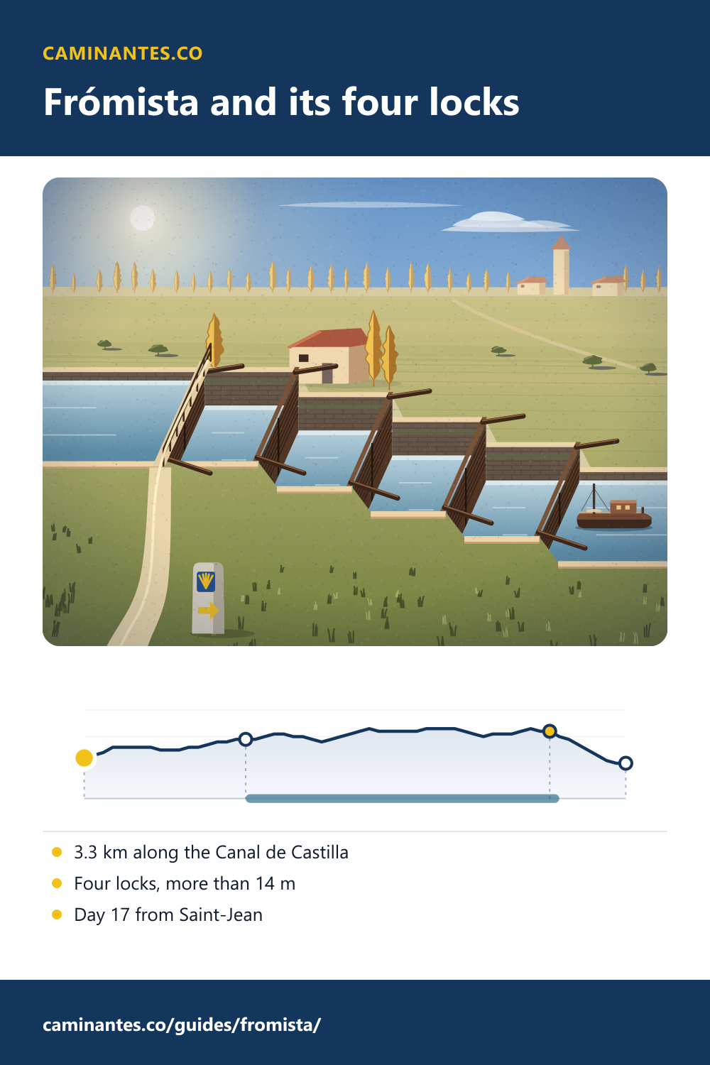
Out of Boadilla the Camino follows the towpath of the Canal de Castilla for 3.3 km, then crosses the canal on the top gate of a staircase of four locks and walks into Frómista, to one of the best-known Romanesque churches in Spain. It is a morning without a hill: only 13 m between its highest and lowest points. On our plan Frómista comes early on day 17 from Saint-Jean, with 419.5 km to go.
The Canal de Castilla: walking the towpath
1.7 km out of Boadilla the Camino reaches the Canal de Castilla and follows its bank for 3.3 km on our track, all the way to the locks. The canal was begun in 1753 to carry the wheat of Castile north to the ports, and finished in 1849: 207 km in all. The railway made it obsolete, and the last boats went in 1959. Today it waters the fields, and its old towpaths, the caminos de sirga, are for walking.
- Boadilla del Camino0.0 km · 782 m · 0 m ↑
- The Canal de Castilla1.7 km · 789 m · 9 m ↑
- The four locks4.9 km · 790 m · 13 m ↑
- San Martín de Tours5.7 km · 780 m · 13 m ↑
The four locks: where the Camino crosses
Just before Frómista the canal steps down in a staircase of four locks, numbered 17 to 20, that took the boats up or down more than 14 m. The Camino crosses the canal on the top gate, 4.9 km from Boadilla and 0.7 km before the middle of town. Stop on the footway and look down the steps: each chamber is a little lower than the one before.
San Martín de Tours
San Martín was built in the second half of the 11th century, by order of doña Mayor of Castile, as part of a monastery that is now gone; from 1118 it belonged to the Cluniac priory of San Zoilo in Carrión. It is small and almost perfectly regular: three round apses at the east end, an octagonal lantern over the crossing, two round towers on the main front, and more than 300 small carved corbels under the eaves. It was declared a national monument in 1894 and restored by the architect Manuel Aníbal Álvarez until 1904; the most worn capitals and corbels went to the museum in Palencia, and copies took their place.
A morning without a hill
From Boadilla at 782 m to San Martín at 780 m is 5.7 km, and on our profile the highest and lowest points of the whole walk are only 13 m apart, with 13 m of climbing in all. The water does the climbing here: the locks lift a boat more than 14 m in one short staircase.
Where it is on the walk
On our plan of 36 days from Saint-Jean, day 17 runs from Boadilla del Camino to Carrión de los Condes: 24.8 km and 102 m of climbing. Frómista comes 5.6 km into the day, and 19.3 km more take you on to Carrión de los Condes. From Frómista it is 419.5 km to Santiago, 19 more days. From Burgos it is day 4. Day 16, the day before, ends in Boadilla.
Know these words before your Camino. Spanish is preparation, the same as boots and stages. Try the free topic
The day before, the arch of San Antón and the climb over Mostelares: Castrojeriz.
Two days on, the middle of the Camino Francés, measured: Sahagún.
The whole meseta, day by day: the Camino from Burgos.
Every stage of the Francés, one by one: the stages guide.
Distances and heights: our own track and elevation profile of the Camino Francés, the same the stages and Burgos pages use; the towpath is the stretch of our track along the canal, and the crossing is the top lock gate in OpenStreetMap. The canal, its dates and the numbers of the four locks: Spanish Wikipedia, Canal de Castilla. More than 14 m: the Castrojeriz to Frómista stage on alberguescaminosantiago.com. The church: Spanish Wikipedia, Iglesia de San Martín de Tours.
Common questions
How long is the walk along the Canal de Castilla?
3.3 km on our track, from 1.7 km out of Boadilla del Camino to the locks just before Frómista. It is flat all the way.
What are the locks at Frómista?
A staircase of four locks on the Canal de Castilla, numbered 17 to 20, that took the boats up or down more than 14 m. The Camino crosses the canal on the top gate, 0.7 km before the middle of Frómista.
Why is San Martín de Frómista famous?
It is often called one of the purest Romanesque churches in Spain: built in the second half of the 11th century, with three apses, an octagonal lantern, two round towers and more than 300 carved corbels. It was restored between 1894 and 1904.
Which day of the Camino Francés is Frómista?
Day 17 from Saint-Jean on our plan, day 4 from Burgos. The town comes 5.6 km into the day from Boadilla del Camino to Carrión de los Condes, 24.8 km, and it is 419.5 km to Santiago.
Keep reading
Carrión de los Condes and the long road with no village
Out of Carrión the Camino Francés runs 17.1 km on the old Roman road with no village, the longest gap between two villages on the whole route. Pick your pace and walk it with the clock running.
Palas de Rei: the hardest day from Sarria, over the Sierra Ligonde
Walk the day from Portomarín in five pictures: past the hillfort, up to the highest point between Sarria and Santiago, down to Palas de Rei. 24.9 km.
Rabanal del Camino: halfway up to the Cruz de Ferro
From Astorga to the stone village of Rabanal in five pictures: the gentle half of the climb to the cross, walked and measured, with the monks’ chant at the end.
Take it with you
Caminantes is free, works offline, and plans your stages around your own legs rather than a guidebook's.