Caminantes
León to Hospital de Órbigo: the road or Villar de Mazarife
By August Frederik Kramer · Last updated 26 October 2026
0.0km to where they meet
0villages on the way
0.0km beside the N-120
Pick a way and watch it draw itself on the plain.
Road way, by Villadangos24.1 kmvillages on the way: 4 · km beside the N-120: 22.3
Field way, by Villar de Mazarife26.7 kmvillages on the way: 5 · km beside the N-120: 0.2
Download the poster (PNG)Free to print and share. Please keep caminantes.co on it.
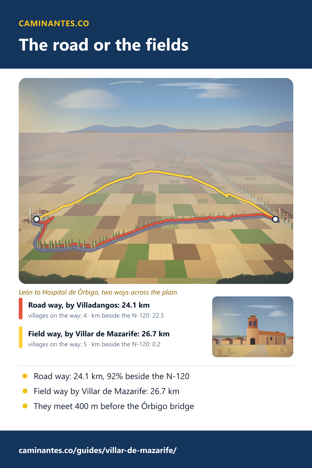
Just out of León, at La Virgen del Camino, the Camino Francés splits in two. The old way follows the N-120 by Villadangos del Páramo: 24.1 km, and 22.3 km of it within 100 m of the road. The other goes out across the fields by Villar de Mazarife: 26.7 km, 2.6 km more, and almost none of it beside the road. They meet again 400 m before the long bridge at Hospital de Órbigo.
The two ways, measured
The way splits 7.5 km out of León, at the far end of La Virgen del Camino, and the two halves meet again at Puente de Órbigo. Between those two points the road way is 24.1 km and the field way 26.7 km: 2.6 km more by the fields. Gronze, the Spanish guide, gives the difference as 4.2 km. Ours is measured along each way’s own line on the map, from the same split to the same meeting point. Neither way has a hill worth the name: 77 m of climbing in all by the road, 76 m by the fields.
How much of the road way is road
22.3 of its 24.1 km run within 100 m of the N-120, the main road from León to Astorga: 92%. The path runs alongside it nearly all the way, through Valverde de la Virgen, San Miguel del Camino, Villadangos del Páramo and San Martín del Camino. The field way is beside the N-120 for 0.2 km, right at the start.
La Virgen del Camino. 7.1 km out of León. Thirteen bronze figures, each six metres tall, stand across the front of the basilica. Just past it the way splits.
The road way. Beside the N-120 by Villadangos del Páramo: 92% of this way runs within 100 m of the road, past 4 villages.
Villar de Mazarife. 20.7 km from León on the field way, about as far as the plan’s first day to Villadangos, 20.2 km. Gronze ends its stage by the fields here.
The Órbigo bridge. The ways meet at Puente de Órbigo, 400 m before the bridge. Hospital de Órbigo is on the far side: 32.4 km from León by the road, 35.0 km by the fields.
La Virgen del Camino
The basilica is the last big building before the split, 7.1 km out of León. It was built from 1957 to 1961 to a design by a Dominican friar, Francisco Coello de Portugal: a plain modern church with no ornament on its walls. Across its front stand thirteen bronze figures by Josep Maria Subirachs, Mary and the twelve apostles, each six metres tall. Saint James is covered in shells and points the way to Santiago. The 50 m concrete bell tower stands apart from the church.
Know these words before your Camino. Spanish is preparation, the same as boots and stages. Try the free topic
Villar de Mazarife
The village takes its name from the Mazaref, a family of Mozarabs from Córdoba recorded in the area from the 890s, who resettled this part of the plain. Saint James is its patron. On the field way it is 20.7 km from León, about as far as the plan’s first day to Villadangos del Páramo, 20.2 km, so it ends the same day. From there it is 29.7 km to Astorga, against 27.6 km from Villadangos.
Which one?
Take the road way for the shorter day and a village every few kilometres: the longest gap is 7.6 km. Take the field way to get away from the traffic, on farm tracks between the fields, for 2.6 km more. Its one long empty stretch is the 9.8 km from Villar de Mazarife to Villavante, with no village at all, so fill your bottle before you leave. Either way you cross the same bridge into Hospital de Órbigo.
The days in figures
On our plan, León to Villadangos del Páramo is the first day out of León, 20.2 km, and Villadangos to Astorga the second, 27.6 km, over the Órbigo bridge. León to Hospital de Órbigo is 32.4 km by the road and 35.0 km by the fields. From León it is 304.6 km to Santiago.
The whole way from León, day by day: the Camino from León.
Where the two ways meet: the bridge at Hospital de Órbigo, walked across.
Every stage of the Francés, one by one: the stages guide.
Distances, climbs and days are measured on our track of the Camino Francés, the same rows the León and Hospital de Órbigo pages print. The field way is the alternative mapped in OpenStreetMap, measured on its own line and its own height profile. “Beside the N-120” means within 100 m of the road as OpenStreetMap maps it. The villages are placed from OpenStreetMap. The basilica, its dates, its architect, the figures and the tower are from the Spanish Wikipedia on the basilica; the name of Villar de Mazarife from the Spanish Wikipedia on the village; Gronze’s figure from its stage to Villar de Mazarife.
Common questions
Is the Villar de Mazarife route longer?
Yes. From the split at La Virgen del Camino to where the ways meet, it is 26.7 km against 24.1 km by the road: 2.6 km more on our map. Gronze says 4.2 km more.
How far is it from León to Villar de Mazarife?
20.7 km on the field way, about as far as León to Villadangos del Páramo on the road way, 20.2 km.
How far is it from León to Hospital de Órbigo?
32.4 km by Villadangos del Páramo, 35.0 km by Villar de Mazarife.
Does the main route really follow the road?
Mostly. 22.3 of its 24.1 km are within 100 m of the N-120.
Where do the two routes meet again?
At Puente de Órbigo, 400 m before the bridge into Hospital de Órbigo.
Keep reading
Sahagún to Mansilla: the Real Camino or the Roman road
Past Sahagún the Camino splits for two days. Pick a way and watch it cross the plain: the Roman road has one stretch of 23.7 km with no village.
Los Arcos to Viana: the octagon of Torres del Río
Walk the last day in Navarra in five pictures, count the climbs between Torres del Río and Viana, and the eight sides of its church. 27.8 km.
Montes de Oca: the forest climb to San Juan de Ortega
Walk Villafranca Montes de Oca to San Juan de Ortega in five pictures: the steep climb into the oaks, the memorial at La Pedraja, the firebreak through the pines. 11.9 km with no village.
Take it with you
Caminantes is free, works offline, and plans your stages around your own legs rather than a guidebook's.