Caminantes
Sahagún to Mansilla: the Real Camino or the Roman road
By August Frederik Kramer · Last updated 26 October 2026
Tap a way. It draws itself across the plain and lights up each village it passes.
Real Camino the main way
13.1km with no village: the longest stretch
El Burgo Ranero to Reliegos
36.6 km from Sahagún to Mansilla, 3 villages on the way, 113 m of climbing.
Calzada Romana the Roman road
23.7km with no village: the longest stretch
Calzadilla de los Hermanillos to Mansilla
37.1 km from Sahagún to Mansilla, 2 villages on the way, 127 m of climbing.
Both ways are flat, and the Roman road is only 0.5 km longer. The difference is company: its empty stretch is 1.8 times as long.
Download the poster (PNG)Free to print and share. Please keep caminantes.co on it.
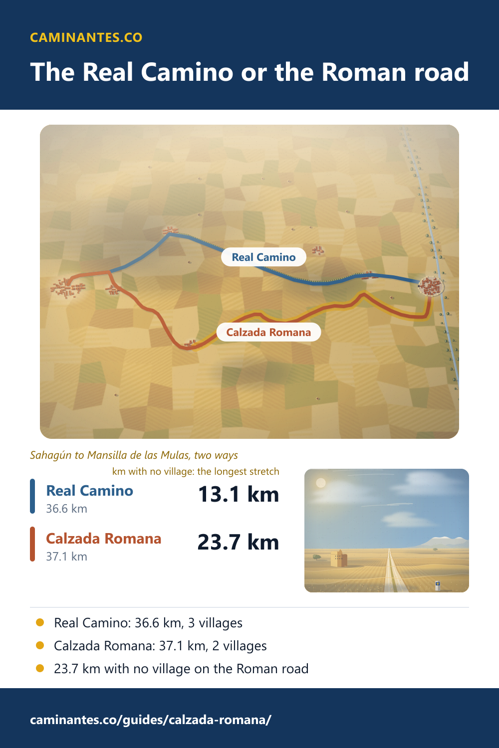
Just past Sahagún the Camino Francés splits in two, and the two ways meet again two days later at Mansilla de las Mulas. The Real Camino, the main way, is 36.6 km with 3 villages on it. The Calzada Romana, the old Roman road, is 37.1 km with 2, and after the second comes 23.7 km with no village at all. Pick a way and watch it walk.
Two ways, measured
On our track the ways part 4.3 km out of Sahagún, where the Roman road turns up into Calzada del Coto, and they meet again at Mansilla. From that turn to Mansilla the Roman road is 32.8 km, 0.5 km more than the Real Camino. Gronze, the Spanish pilgrim guide, gives 32.2 km and says it adds 800 m. Both ways are flat: from Sahagún to Mansilla the Real Camino climbs 113 m in all, the Roman road 127 m.
The longest stretch with no village
On the Real Camino the longest gap between villages is 13.1 km, from El Burgo Ranero to Reliegos, on a gravel path beside a quiet road where a row of trees was planted for shade. On the Roman road, after Calzadilla de los Hermanillos, there is no village for 23.7 km, all the way to Mansilla. Gronze gives 23.8 km for that stretch. Carry water and food from Calzadilla.
Calzada del Coto. 4.3 km out of Sahagún the ways part. The Real Camino goes straight on beside the road and its row of trees. The Roman road turns right, up the street of Calzada del Coto.
Calzadilla de los Hermanillos. 13.4 km from Sahagún. Calzadilla de los Hermanillos is the last village on the Roman road, and it has a pilgrim hostel. Fill your water bottles: the next village is Mansilla, 23.7 km on.
The empty stretch. Halfway across, 25.3 km from Sahagún. A straight track over the fields and the sky all round. The last village is 11.9 km behind you, and the next is 11.9 km ahead.
Mansilla de las Mulas. 37.1 km from Sahagún. The track runs in under the old town walls of river stones and lime, and the two ways are one again.
37.1km from Sahagún
23.7km to the next village
Sahagún to Mansilla on the Roman road: 37.1 km. 23.7 km of it with no village. From Mansilla, 323.6 km to Santiago.
Why it is called the Roman road
Guides call this way the Calzada Romana or the Vía Trajana, after the Roman road it follows. Calzada del Coto, where it starts, takes its name from that road: from the 11th century the village was called Villa Calzata, for the old Roman road that had become a pilgrim way. Gronze calls it well waymarked, and much lonelier than the main way.
Know these words before your Camino. Spanish is preparation, the same as boots and stages. Try the free topic
Which way should you take?
If you want company and a village every few kilometres, take the Real Camino. Our plan does: day 20 from Sahagún to El Burgo Ranero, 17.7 km, and day 21 on to Mansilla, 18.9 km. If you want a quiet day, take the Roman road and sleep in Calzadilla: 13.4 km the first day, 23.7 km the second. The second day is the long one, and it has no village at all.
Mansilla de las Mulas
Both ways end under the walls of Mansilla de las Mulas, built of river stones and lime. In places they stand more than 14 m high and 3 m thick. They probably date from before 1181, when King Fernando II of León resettled the town, and of their four gates the Arco de Santa María still stands whole. From Mansilla it is 323.6 km to Santiago; León is the next day on our plan, 19.0 km on.
The day before, and the middle of the Camino: Sahagún, measured.
Every day of the walk: the Camino Francés stage by stage.
Sources: km, climbing and villages measured on our own tracks, the Roman road from OpenStreetMap. Guidebook figures from Gronze (Calzadilla de los Hermanillos, Bercianos to Mansilla). History from Spanish Wikipedia (Calzada del Coto, Mansilla de las Mulas). All read 26 October 2026.
Common questions
Is the Calzada Romana longer than the Real Camino?
Only a little. From Sahagún to Mansilla de las Mulas we measure 36.6 km on the Real Camino and 37.1 km on the Calzada Romana, 0.5 km more. Gronze says 800 m more.
How far is it with no village on the Calzada Romana?
23.7 km, from Calzadilla de los Hermanillos to Mansilla de las Mulas; Gronze gives 23.8 km. On the Real Camino the longest stretch with no village is 13.1 km.
Where do the two ways split and meet again?
They split 4.3 km out of Sahagún, where the Calzada Romana turns up into Calzada del Coto, and meet again at Mansilla de las Mulas.
Is the Calzada Romana waymarked?
Yes. Gronze calls it well waymarked and much lonelier than the main way. Calzadilla de los Hermanillos, the last village on it, has a pilgrim hostel.
Keep reading
Los Arcos to Viana: the octagon of Torres del Río
Walk the last day in Navarra in five pictures, count the climbs between Torres del Río and Viana, and the eight sides of its church. 27.8 km.
Montes de Oca: the forest climb to San Juan de Ortega
Walk Villafranca Montes de Oca to San Juan de Ortega in five pictures: the steep climb into the oaks, the memorial at La Pedraja, the firebreak through the pines. 11.9 km with no village.
Atapuerca: the oldest Europeans, and the cross above Burgos
Walk from San Juan de Ortega over the stony sierra to the cross above Burgos, then dig down through the caves of the oldest Europeans, one find at a time. Atapuerca to Burgos: 18.4 km.
Take it with you
Caminantes is free, works offline, and plans your stages around your own legs rather than a guidebook's.