Caminantes
Portomarín on the Camino: the drowned town, the church that moved, and the 100 km line
By August Frederik Kramer · Last updated 13 October 2026
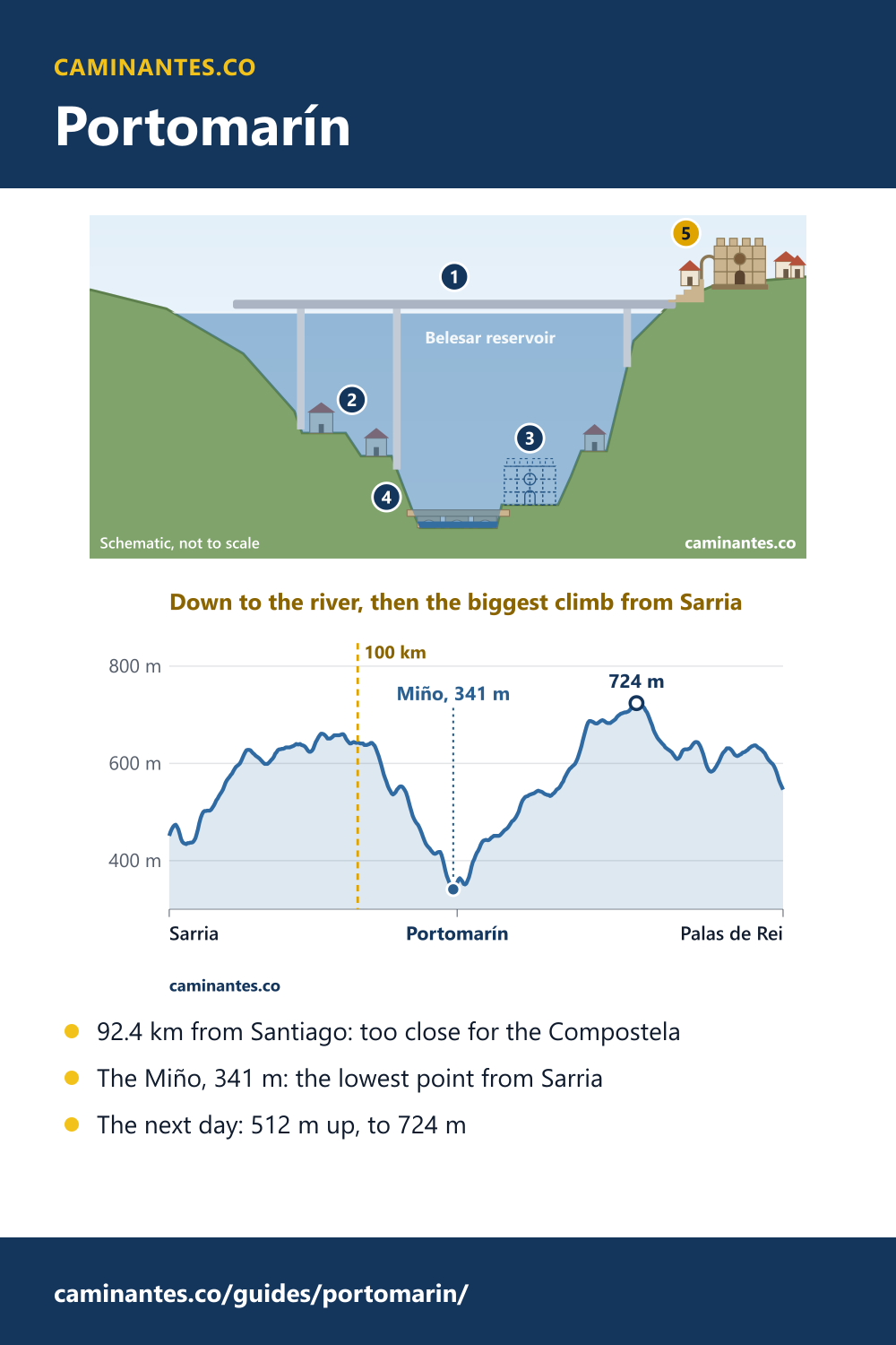
Today the Miño here is the Belesar reservoir. You cross it on a long, high bridge, then climb stone stairs into the town on the hill.
That is Portomarín. The old town lies under the reservoir, and when the water is low its bridge and walls come back into sight. The church on the hill is the one that stood by the river.
Tap the button to lower the water, one step at a time.
- The new bridgeToday the Miño here is the Belesar reservoir. You cross it on a long, high bridge, then climb stone stairs into the town on the hill.
- The old townThe water drops and the old town comes back: the walls of its houses and the waterfront.
- Where the church stoodLower still: the place by the river where the church of San Nicolás stood.
- The old bridgeAt the bottom, the old bridge: Roman, rebuilt in the Middle Ages, the way pilgrims crossed the Miño for centuries.
- The church on the hillWhen the reservoir came, the church was taken apart, its stones numbered, and rebuilt on the hill.
Portomarín is the first night out of Sarria, and on our track it is 92.4 km from Santiago: 7.6 km too close to start from if you want the Compostela. It sits on a hill above a reservoir that drowned the old town in 1962, with a church that was moved up the hill stone by stone. Below it, the Miño at 341 m is the lowest point between Sarria and Palas de Rei, and the next morning is the biggest climb of the whole walk from Sarria.
Can you start in Portomarín?
Not if you want the Compostela. The Pilgrim’s Office asks for the last 100 km on foot, and Portomarín is 92.4 km from Santiago on our track: 7.6 km short. Sarria, 114.4 km out, is the last stage town that clears the line, and you cross the line 14.4 km after Sarria, on the way here.
Where the line falls on every route: the last 100 km.
The day in: Sarria to Portomarín
It is 22.0 km, with 339 m of climbing and 440 m of descent. The last stretch falls to the Miño at 341 m, the lowest point between Sarria and Palas de Rei, 0.3 km before the end of the stage. In the busiest month about 1,104 people a day walk out of Sarria on this road, so the first night is a busy one.
Download the poster (PNG)Free to print and share. Please keep caminantes.co on it.
All five days from Sarria: Sarria to Santiago.
The town under the water
Old Portomarín stood by the Miño, at a Roman bridge rebuilt in the Middle Ages. In 1962 the Belesar reservoir was built, and the town moved up the neighbouring hill, Monte do Cristo, where some of its most important buildings were put back up. When the water is low, the remains of the old buildings, the waterfront and the old bridge still come into sight. Coming in, you climb a stone stairway from the bridge; local guides describe it as built on an arch of the old bridge, with the small chapel of the Virgen de las Nieves at the top.
The church that moved
The Romanesque church of San Nicolás, also called San Juan, was built by the Order of St John of Jerusalem, which granted the town its charter in 1212, and it was declared a national monument in 1931. When the town moved, the church was taken apart, its stones were numbered, and it was put together again on the hill. It looks more like a castle than a church: look for the battlements along the top and the rose window over the door.
Know these words before your Camino. Spanish is preparation, the same as boots and stages. Try the free topic
The morning after: Portomarín to Palas de Rei
The next day is 24.9 km with 512 m of climbing, more than any other day from Sarria. From the river at 341 m the path climbs 383 m in 14.0 km, to 724 m, 13.7 km out of town: the highest point between Sarria and Santiago. In all, the day goes down 318 m. Start early, and keep something for the afternoon.
Where the morning after ends: Palas de Rei, the climb over the Sierra Ligonde walked in five pictures.
Every stage of the Francés, one by one: the stages guide.
Where the Primitivo joins the Francés, and the pulpo: Melide.
Distances and heights are from our stage plan and our elevation profile of the Camino Francés, sampled every 100 m. The drawing of the valley is a schematic, not a survey. The history is from the Spanish Wikipedia articles on Portomarín and on its church of San Juan, and the English Wikipedia article on Portomarín.
Common questions
How far is Portomarín from Santiago?
92.4 km on our track, 4 days on foot on our plan.
Can you get the Compostela starting in Portomarín?
No. Portomarín is 92.4 km from Santiago, 7.6 km short of the 100 km the Pilgrim’s Office asks for. Start in Sarria, 114.4 km out.
How far is it from Sarria to Portomarín?
22.0 km, with 339 m of climbing and 440 m of descent, down to the Miño at the end.
Why was Portomarín moved?
The Belesar reservoir on the Miño, built in 1962, flooded the old town. The town was rebuilt on the hill above it, and its church was moved there stone by stone.
How hard is the stage from Portomarín to Palas de Rei?
24.9 km and 512 m of climbing, the most of any day from Sarria, up to 724 m.
Keep reading
Monte do Gozo: the cathedral is 5.0 km away and 97 m below
Walk the last stretch from Lavacolla, spot the spires from the Hill of Joy, and see why the first to see them was crowned king.
The bridge at Hospital de Órbigo is 300 m long. The river needs about 20.
Cross it with one button, break a lance with the knight of the Paso Honroso halfway, and see why so much bridge spans so little water.
The Camino from Pamplona: 33 days to Santiago, the Pyrenees already behind you
Day one climbs to the metal pilgrims of the Alto del Perdón. 701.1 km in all, and leaving out the first 3 days saves 9% of the walking but 17% of the climbing.
Take it with you
Caminantes is free, works offline, and plans your stages around your own legs rather than a guidebook's.